
Obertagstein Castle
| Obertagstein Castle | ||
|---|---|---|
 Obertagstein Castle above Thusis |
||
| Creation time : | around 1300 | |
| Castle type : | Hilltop castle | |
| Conservation status: | ruin | |
| Construction: | Rubble stones | |
| Place: | Thusis | |
| Geographical location | ||
| Height: | 1150 m above sea level M. | |
|
||

The ruins of Obertagstein Castle are located in the municipality of Thusis in the Swiss canton of Graubünden .
location
The ruin of the hilltop castle is 1150 m above sea level. M. at the appendix of Piz Beverin on a rock head that slopes vertically on all sides south-west of Thusis. At the foot of the rock, a mule track led past the Saissa Alp. The castle can be easily reached on foot from Thusis in about an hour, first via a forest road, and finally via a steep forest path. The access to the castle was renewed in 2015, so it can now safely be visited inside.
Surname
In the twelve documents recorded up to 1500, nine are in the form of Tagstein or similar. When it was first mentioned in 1322, however, the form Taxstein ( … ze Taxstein uf der Burch ), 1360 Taxstain and 1487 even Tachsstain , and in 1538 the castle is still called Taxstein . Therefore, a derivation of the name from the badger (Latin taxus ) seems to be considered: a place where badgers stay. Since the older evidence indicates the badger, it can be assumed that the change from Taxstein to Tagstein took place, facilitated by the omission of a consonant.
investment
The complex lies behind a mighty shield wall that protected the actual castle uphill. The walls are built from rubble stones , occasionally in Opus spicatum .
The complex was built in at least two phases, which suggests that it will be inhabited for a longer period of time. The planning concept with shield wall and Palas and comfortable furnishings suggest a rather late time it was built in the late 13th century.
The oldest part only took up the western corner of the rock head and consisted of a five-storey hall leaning against the shield wall. Access was at ground level from the east. There was a lavatory to the north . In the south-west corner, a powerful round smoke outlet can be seen. At the height of the fifth floor in the middle of the wall there is a double arched window with tuff walls . The oldest building stock includes a cistern that was set into a natural crevice on the inside of the shield wall. The water was led directly into the cistern through the roof and wooden gutters via a small channel under the window sill, as can still be seen.

Obertagstein ruin

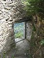
Access

Bridge to the entrance

Shield wall

Double window


Access was through a later walled-up gate on the southwest corner. The beam holes for the wooden staircase are below the gate. A narrow kennel led from the gate over a narrow ledge to a gate on the southeast side. As can be seen from the inside of the shield wall, the palas was no higher than two storeys on the north inner side; although another, wooden upper floor cannot be completely ruled out.

Entrance to the former cistern vault

Shield wall from the inside

North wall

Sill window


In a second expansion phase, the building was expanded to include the entire rock and the previously undeveloped part in the east was enclosed by a wall. The previous toilet bay was converted into a bay window and a new toilet bay was built east of it in the new wall, which, incidentally, is still used today, as a look over the wall shows. The kitchen was in the southeast. Remains of grain and nutshells were found in the rubble, as well as parts of some kitchen utensils such as chopping knives and copper kettles.

walled up former gate

Aborterker
High entrance on the north side

Southeast corner


The new entrance led from the southern outer fence over a wooden bridge to the lower-lying new gate in the east over the vertically sloping abyss. A staircase led up to the hall.
After the shield wall at the cistern had slipped, the gate system was relocated from the east side into the breach that had been created. As it is today, the gate could be reached via a wooden bridge and led through the former cistern room into the interior. The original gate to the Zwinger was walled up and an arrow slit was built into the wall.
From the man-made terracing in the south-western fore area there were probably economic buildings, of which no remains have survived.
Obertagstein was verifiably destroyed by fire in the late 14th century. Red inscriptions in the plastering of the window reveals date from the 16th century.

View to Hohenratsien Castle

View to Thusis
Fore area

Layout


history
There are no written documents about the origins and history of the castle; who lived in the castle is not known. There was no aristocratic family that named themselves after Tagstein, as the aristocratic names had already been established by the time they came into being. The name Tagstein is related to the Untertagstein Castle in Masein . In 1385 and 1387 Obertagstein was indirectly mentioned by naming Untertagstein.
Around 1980 the ruins were uncovered, structurally secured and archaeologically examined by Lukas Högl under the direction of Felix Nöthinger by the Graubünden Castle Association. It was on this occasion that the aforementioned finds came to light.
literature
- Fritz Hauswirth: Castles and palaces in Switzerland. Volume 8 . Neptun Publishing House. Kreuzlingen, 1972
- Otto P. Clavadetscher, Werner Meyer : The castle book of Graubünden . Zurich 1984, ISBN 3-280-01319-4
- Anton von Castelmur: "The castles and palaces of the Canton of Graubünden", Volume II, Birkhäuser-Verlag, Basel 1940
- Heinrich Boxler, naming castles in north-eastern Switzerland and in Graubünden , Huber Verlag, Frauenfeld 1976
- Castle map of Switzerland, 2007 edition, Federal Office of Topography / Swiss Castle Association
Web links
Individual evidence
- ^ Heinrich Boxler: The naming of castles in north-eastern Switzerland and in Graubünden ; P. 121f

Episcopal Castle Fürstenau | Old Aspermont | Old Süns | Balcun At | Baldenstein | Bear Castle | Belfort | Belmont | Bernegg | Brandis | Cagliacha | Calanca | Campell | Cana scarf | Cartacha | Castelberg | Castelmur | Castels | Castrisch | Crap da Sass | Crap Sogn Parcazi | Ehrenfels | Fracstein | Falkenstein | Frauenberg | Friberg (Siat) | Friberg (Trun) | Friedau | Grafenberg | Greifenstein | Grotto stone | Grüneck | Grünenfels | Guardaval | Haldenstein Castle | Haldenstein Castle | Hasensprung | Heidenberg | Heinzenberg | High Juvalt | Hohenbalken | High Councilors | Innerjuvalt | Jörgenberg | Kapfenstein Castle | Blade horn | Kropfenstein | Lagenberg | La Serra dam | La Tur | Lichtenstein | Löwenberg | Lion's Arch | Marmels | Marschlins | Mesocco | Moregg | New Aspermont | New Süns | Neuburg | Nivagl | Norantola | Ober-Ruchenberg | Obertagstein | Ortenstein | Piping | Pontaningen | Rappenstein | Rhäzüns | Rietberg | Ringgenberg | Riom | Rohan | Salenegg | Salons | Saxenstein | Schauenstein | Schiedberg | Tower of Schlans | Schwarzenstein | Serviezel | Solavers | Spaniola | Splash | Splügen | Sta. Maria in Calanca | Steinsberg | Strahlegg | Strassberg | Surcasti | Tarasp | Torre Palas | Tschanüff | Tuor | La Praschun Tower | Turraccia | Valendas | Vogelberg | Wackenau | Wildenberg (Falera) | Wildenberg (Zernez) | Wynegg