
Fracstein Castle
| Fracstein Castle | ||
|---|---|---|
 Rest of the wall on the valley side |
||
| Creation time : | around 1200 | |
| Castle type : | Höhenburg, cave castle | |
| Conservation status: | ruin | |
| Standing position : | Free nobles | |
| Construction: | Quarry stone | |
| Place: | Seewis in the Prättigau | |
| Geographical location | 46 ° 58 '30 " N , 9 ° 36' 56" E | |
|
||

The Fracstein Castle is the ruin of a rock castle on the territory of the municipality Seewis in the Klus at the entrance to Prättigau in the Swiss canton of Grisons .


location
Fracstein Castle stood at the foot of a rock face on the right side of Landquart . Fracstein's importance lay in its location on the road connecting the Lake Zurich area to the Flüelapass . Access: From the old cantonal road, a small passage leads through the retaining wall to the rubble dump at the foot of the rock face. The ruin can be easily reached in five minutes via a narrow, steep path.
Surname
There is little clarity about the origin of the name. In and of itself, the interpretation saxa fracta would fit the location of the castle at the foot of a vertically sloping rock face. In the documents, however, the name appears four times as a question mark , the first time in 1338, the last time in 1509; In 1344 the Fragstein castle is mentioned once .
Ulrich Campell considers the origin of the name to be German and suspects a connection with the Middle High German verb varsh (= to ask, to research), which would only make sense in connection with a customs post. It is also difficult to understand why a medieval lord of the castle should name his castle in the middle of the Rhaeto-Romanic- speaking area after a German verb. It seems more logical to come from an original name Ragenstein (under the rising rock), which could have led to Frakstein through Ragenstein . It can no longer be determined whether the first part of the word is of Romance or German origin. Apparently the name was no longer understood in Campell's time around 1573.
investment
Castle
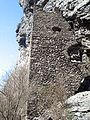
Only a few stone walls of the main building remain, sometimes in Opus spicatum . The main wing consisted of an elongated rectangle with a recessed extension on one of the northern narrow sides. The back of the castle consisted of the natural, protruding rock that formed a mighty protective roof. Inside, an irregular construction joint indicates that the building was built on the rubble of an older building. Of particular interest is the water supply: Since neither Sodbrunnen still a cistern that could be created, the water was taken west of the castle above the cliff and out with wooden pipes to the castle.
The building consisted of four floors, the third of which was developed as a residential floor. The main living rooms were on the third floor, of which one window still has a seating niche. As can be seen from the recesses in the interior plaster, the individual floors were divided with wooden walls. The high entrance at the level of the second floor is still well preserved on the narrow eastern side. It was accessible through a staircase on the east side. The wall on the valley side was closed with battlements at a wide distance. The roof was probably built against the rock and sloped away to the south.
drawings
The numerous incised drawings in the plaster on the eastern inner side of the residential building are noteworthy; if you know where to find them, you can still see them. They date from the High Middle Ages and depict various helmets and coats of arms of some local knight families such as the Aspermont , the Belmont, the Rhäzüns and others.
House of the castle priest and church
In the immediate vicinity of the main building are the remains of a small, formerly three-story residential building, which was probably the accommodation of the so-called "Burgpfaffen". The living room was on the second floor. Immediately next to it was a small church dedicated to St. Aper , which was mentioned for the first time in 1370 and for the last time in 1520. Today only a few foundations can be seen. The house leaned against the rock face and consisted of a diagonally divided building with a steep monopitch roof . Inside you can still see wall niches, remains of a pouring stone and a heating system.
Wall
The Letzimauer , which led from the foot of the wall to the bank of the Landquart and sealed off the gorge, has also practically disappeared . However, a picture by Wolf Huber von Fracstein from 1552 has survived, showing the building, which was already in ruins at the time. You can also see the chapel and the wall, which is reinforced with loopholes and battlements. On the street was a gate with a cast bay window, which was covered by a pointed arch. The wooden door wings were reinforced with sheet iron and iron bars, which is why the name Ferraporta (iron door) came up, which was carried over to the nearby castle complex in a different form. In 1799, Graubünden troops tried in vain to stop the French invasion of Fracstein. By falling rocks, using it as a quarry and building the railway line and the modern road, the Letzimauer was destroyed with the exception of small remains.
history

It is not known when Fracstein was built; there are no references in this regard. In the 13th century the castle was owned by the Aspermont rulers , who at that time established a successful rule in the Maienfeld region and in the lower Prättigau. Presumably they were the builders of the main castle. Fracstein first appears in texts in the 14th century, when the rule of Aspermont was divided. In 1338 Eberhard and Ulrich von Aspermont sold the inheritance of their uncle Ulrich in the Prättigau to Friedrich V of Toggenburg and Ulrich von Matsch . They kept the lands until 1344, when they were divided. Fracstein remained in the possession of the two families, but came to the Prättigau and from then on shared the fate of the valley.
In 1436, Frederick VII, the last Count of Toggenburg, died, and Fracstein passed to the Knights of Matsch, who sold the castle to Austria in 1466. The buildings were no longer maintained and fell into disrepair. Fracstein was a ruin in the 16th century. The chapel, mentioned for the first time in a document from 1370, seems to have been in use until the Reformation around 1530. It later served as a backdrop for a traditional rural spring festival for a long time.
Fracstein played a role again in the turmoil of the 17th century: in 1621 the old dam was repaired by Colonel Alois Baldiron , and in 1622 there was even a small Austrian garrison in the castle until it was chased away by the rebellious inhabitants of the Prättigau. In 1649 the Prättigau Six-Court Association bought itself out of Austria, and Fracstein became the property of the court of Schiers.
photos
East side with the current entrance, in the middle the former high entrance

Fracstein lies at the foot of the rock face

South wall against the ravine

Drawings on the east wall

reconstruction

House of the Burgpfaffen

South facade of the Pfaffenhaus

eastern inner wall


literature
- Werner Meyer : Castles of Switzerland. Volume 3: Canton of Graubünden. German and Romance parts. Zurich 1983.
- Maria-Letizia Boscardin: The Fracstein Castle Grotto and its incised drawings . In: Swiss contributions to the cultural history and archeology of the Middle Ages . Volume 4, Olten 1977.
- Fritz Hauswirth: Castles and Palaces in Switzerland , Volume 8, Neptun, Kreuzlingen, 1972.
- Anton von Castelmur: The castles and palaces of the Canton of Graubünden , Volume I, Birkhäuser, Basel 1940.
- Castle map of Switzerland, 2007 edition, Federal Office of Topography / Swiss Castle Association.
- Heinrich Boxler: The naming of castles in northeastern Switzerland and in Graubünden. Huber, Frauenfeld 1976.
Web links
- Castle world: Fracstein cave castle
- Fracstein castle ruins at www.graubuendenkultur.ch .
Individual evidence
- ↑ http://www.frag-caesar.de/lateinwoerterbuch/saxum-uebersetzung.html Latin dictionary
- ^ Heinrich Boxler: The naming of castles in northeastern Switzerland and in Graubünden. P. 113f

Episcopal Castle Fürstenau | Old Aspermont | Old Süns | Balcun At | Baldenstein | Bear Castle | Belfort | Belmont | Bernegg | Brandis | Cagliacha | Calanca | Campell | Cana scarf | Cartacha | Castelberg | Castelmur | Castels | Castrisch | Crap da Sass | Crap Sogn Parcazi | Ehrenfels | Fracstein | Falkenstein | Frauenberg | Friberg (Siat) | Friberg (Trun) | Friedau | Grafenberg | Greifenstein | Grotto stone | Grüneck | Grünenfels | Guardaval | Haldenstein Castle | Haldenstein Castle | Hasensprung | Heidenberg | Heinzenberg | High Juvalt | Hohenbalken | High Councilors | Innerjuvalt | Jörgenberg | Kapfenstein Castle | Blade horn | Kropfenstein | Lagenberg | La Serra dam | La Tur | Lichtenstein | Löwenberg | Lion's Arch | Marmels | Marschlins | Mesocco | Moregg | New Aspermont | New Süns | Neuburg | Nivagl | Norantola | Ober-Ruchenberg | Obertagstein | Ortenstein | Piping | Pontaningen | Rappenstein | Rhäzüns | Rietberg | Ringgenberg | Riom | Rohan | Salenegg | Salons | Saxenstein | Schauenstein | Schiedberg | Tower of Schlans | Schwarzenstein | Serviezel | Solavers | Spaniola | Splash | Splügen | Sta. Maria in Calanca | Steinsberg | Strahlegg | Strassberg | Surcasti | Tarasp | Torre Palas | Tschanüff | Tuor | La Praschun Tower | Turraccia | Valendas | Vogelberg | Wackenau | Wildenberg (Falera) | Wildenberg (Zernez) | Wynegg