
Castelmur Castle
| Castelmur ruins | ||
|---|---|---|
 Castelmur Castle and Nossa Donna Church |
||
| Castle type : | Hilltop castle | |
| Conservation status: | ruin | |
| Place: | Promontogno | |
| Geographical location | 46 ° 20 '22.5 " N , 9 ° 33' 41" O | |
| Height: | 930 m above sea level M. | |
|
||

The castle and dam of Castelmur is the ruin of a hilltop castle and a dam on a natural rock bar in the municipality of Bregaglia in Bergell in the Swiss canton of Graubünden .
location
The ruins of Castelmur are 930 m above sea level. M. above the village of Promontogno on a natural rock bar that separates the Vicosoprano valley from the lower valley section of Bondo . The canton road in the Promontogno tunnel passes under the system today.
investment
The structure of the Castelmur dam is essentially divided into three different elements, which were only partially connected to one another.
Top tier: Turraccia
On the top step, on a wide cliff, there are ruins of a tower with a floor plan of around 10 × 10 meters. The elevated position allowed a wide view of the valley. There was no structural connection with the middle tier.
Middle level: feudal castle and Nossa Dona church


The ruins of the former feudal castle lie on an elongated rock ridge north of the Nossa Donna church . A mighty residential tower with remains of the ring and ancillary buildings has been preserved.
The five-storey square keep was built around 1300. It has a ground plan of 12 x 12 meters, the wall thickness is 2.4 meters. The high entrance was in the east wall on the 2nd floor and was accessible via a wooden external staircase. On the 3rd and 4th floors, an inclined smoke outlet for an open fireplace led to the outside. On the third floor of the west wall, a door led to a balcony or an adjacent building. On the south side there was an exit to an arcade leading around the entire tower, the horizon of which can still be seen through the beam holes. The tower was probably covered by a tent roof.
The facility was surrounded by a Bering, which led irregularly around the rock plateau, the gate of which was on the south side. To the west and east of the tower are the remains of walls from outbuildings.
Saddle north of the castle
In the western and eastern ends of the lower saddle in the north of the castle are the remains of a traverse that served to defend the castle. The remains of the building are not recognizable.
Lowest level: Lan Müraia dam
The “Lan Müraia” road block on the terrace above the Mera gorge formed the northernmost and deepest part of the facility. On the west and east sides there was a 3.70 meter thick wall with a gate. Remains of a battlement have been preserved on the valley side . The western wall has crumbled. The roughly 50 cm deep cuts in the eastern gate were probably used to accommodate tree trunks that were laid across. The upper end was formed by a battlement, which partly rested on pillars and arches. In the north of the plateau are the remains of a later built surrounding wall . In the 1920s, the remains of Roman buildings were found on the plateau that belonged to the Roman road station "Murus" mentioned in the Antonine Itinerary ; probably a last-like attachment.
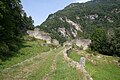
Dam and old valley path, view from the east

upper part of the eastern dam

lower part of the eastern dam

lower part of the eastern dam

western part of the dam


history

Built on the site of the Roman rest station Murus , the “Castellum ad Bregalliam” dam, together with a customs post , is mentioned for the first time as a fiefdom of Constantine in the Churrätischen imperial estate arable from the year 840 . In 960 the Bergell came with the customs law through an exchange deal with King Otto I. to the diocese of Chur . In a document from October 20, 988, the exchange of King Otto III. approved; the “Insuper bergallium cum castellum” festival is expressly mentioned. Later confirmations in the 11th century also all concern the valley with the fort, church and customs.
Around 1121 the Chiavennes forcibly took possession of the castle. Pope Calixt II asked the Chur bishop twice to get the members of his diocese in Chiavenna to return them. A document on the peace between the diocese and the city of Como from 1219 shows that the dam formed the border of the Chur sphere of influence.
The lords of Castelmur appear with Albertus de Castello Muro for the first time in 1190. The ministerial family named themselves after the castle, held it as a castle fief and looked after it on behalf of the Chur bishop. In 1271, Bishop Heinrich documented Castelmur. Around 1340, Bishop Ulrich pledged the castle to the von Planta family for 200 marks . Hartmann von Werdenberg-Sargans redeemed a quarter of the sum in 1393, and around 1410 had to pledge the castle to Jacob Parutt von Castelmur. He had committed himself to Hartmann's predecessor Johannes in 1387 , because he wanted to do ainen weg and lantstraß over the aforementioned mountain [...] and buwen sol, so that one can walk and walk over it with wagons ; In return, he was entitled to 10 years' removal . In 1430 Andreas von Salis -Soglio sat on Castelmur.
The castle lost its military and, above all, economic importance when, after the opening of the Viamala in 1473, the Untere Strasse over the Splügen and San Bernardino passes replaced the Obere Strasse over the Septimer as the main traffic route. In 1490, Bishop Ortlieb handed the castle over to Michael Pfannholz and his wife and daughter for life. They had to undertake to keep the tach, stegen and room in eggs on the sloz . In 1538 the chronicler Tschudi reported that the castle had gone to the teyl . It is not known when the Castelmur settlement was abandoned.
Giovanni von Castelmur (1800–1871) commissioned the restoration of the ruins and around 1845 had the Nossa Donna church rebuilt.
literature
- Thomas Bitterli: Swiss Castle Guide , Friedrich Reinhard Verlag Basel / Berlin, 1995
- Otto P. Clavadetscher, Werner Meyer : The castle book of Graubünden . Zurich 1984, ISBN 3-280-01319-4
- Castle map of Switzerland, Federal Office of Topography, 2007 edition
- Willy Zeller: Art and Culture in Graubünden , Haupt Verlag Bern, 1993
- Fritz Hauswirth: Castles and palaces in Switzerland . Volume 8. Neptun Verlag. Kreuzlingen, 1972
Web links
- Maria-Letizia Boscardin: Castelmur. In: Historical Lexicon of Switzerland .
- Castle world: Castle Castelmur
- Remains of the feudal castle Castelmur on www.baukultur.gr.ch
- Environmental engagement 2015: Lan Müraia, Promontogno
Individual evidence
- ^ Fritz Hauswirth: Castles and palaces in Switzerland . Volume 8.
- ^ Thomas Kühtreiber : Street and Castle. Notes on a complex relationship . In: Kornelia Holzner-Tobisch, Thomas Kühtreiber, Gertrud Blaschitz (eds.): The complexity of the street. Continuity and change in the Middle Ages and early modern times (= publications by the Institute for Reality Studies of the Middle Ages and Early Modern Times . Volume 22 ). Vienna 2012, chap. Burg und Zollstätten: Case studies in a comparison of the history of writing and building history (p. 284), p. 263–301 ( text on academia.edu ).
- ↑ Otto P. Clavadetscher, Werner Meyer: The Burgenbuch von Graubünden .

Episcopal Castle Fürstenau | Old Aspermont | Old Süns | Balcun At | Baldenstein | Bear Castle | Belfort | Belmont | Bernegg | Brandis | Cagliacha | Calanca | Campell | Cana scarf | Cartacha | Castelberg | Castelmur | Castels | Castrisch | Crap da Sass | Crap Sogn Parcazi | Ehrenfels | Fracstein | Falkenstein | Frauenberg | Friberg (Siat) | Friberg (Trun) | Friedau | Grafenberg | Greifenstein | Grotto stone | Grüneck | Grünenfels | Guardaval | Haldenstein Castle | Haldenstein Castle | Hasensprung | Heidenberg | Heinzenberg | High Juvalt | Hohenbalken | High Councilors | Innerjuvalt | Jörgenberg | Kapfenstein Castle | Blade horn | Kropfenstein | Lagenberg | La Serra dam | La Tur | Lichtenstein | Löwenberg | Lion's Arch | Marmels | Marschlins | Mesocco | Moregg | New Aspermont | New Süns | Neuburg | Nivagl | Norantola | Ober-Ruchenberg | Obertagstein | Ortenstein | Piping | Pontaningen | Rappenstein | Rhäzüns | Rietberg | Ringgenberg | Riom | Rohan | Salenegg | Salons | Saxenstein | Schauenstein | Schiedberg | Tower of Schlans | Schwarzenstein | Serviezel | Solavers | Spaniola | Splash | Splügen | Sta. Maria in Calanca | Steinsberg | Strahlegg | Strassberg | Surcasti | Tarasp | Torre Palas | Tschanüff | Tuor | La Praschun Tower | Turraccia | Valendas | Vogelberg | Wackenau | Wildenberg (Falera) | Wildenberg (Zernez) | Wynegg