
Tamina Valley
| Tamina Valley | ||
|---|---|---|
 Mapraggsee below Vättis |
||
| location | Canton of St. Gallen | |
| Waters | Tamina , Ramuzbach , Görbsbach , Chrüzbach | |
| Mountains |
Ringelspitz (3,247 m) Pizol (2,844 m) Calanda massif (2,806 m) |
|
| Geographical location | 755 710 / 202472 | |
|
||
| Type | Sohlental , Kastental | |
| height | 515 to 3247 m above sea level M. | |
| particularities | Tamina Gorge | |


The Taminatal or Vättnertal is a tributary of the Alpine Rhine Valley and from the Tamina drained. It is located in the canton of St. Gallen , a small part in the canton of Graubünden .
geography
The Tamina valley runs from the Kunkelspass to the northeast to Bad Ragaz . At Vättis it joins the Calfeisental , which extends in the west from the mountain range around Piz Sardona over the Walser settlement of St. Martin and the Gigerwaldsee to Vättis. Here the Görbsbach coming from Kunkels flows into the Tamina . In the lowest section of the valley lies the Tamina Gorge with Bad Pfäfers .
In the Tamina valley there are several small villages that belong to the political municipality of Pfäfers : These are the localities Pfäfers, Vättis, Vadura, Valens and Vasön as well as the scattered settlement of St. Margretenberg with Furggels. Northwest above the local community Vättis lies at an altitude of 2427 m above sea level. M. on the Drachenberg the entrance to the Drachenloch .
history
In 1917, bones of a cave bear were found in the Drachenloch. Between 1917 and 1923 two fireplaces were discovered during excavations, and in 1920 a locked stone box with charcoal was found in one passage. The Swiss Society for Prehistory and Protohistory dated the charcoal to be more than 53,000 years old.
In the Tamina Valley there are four geological sites in the Sardona Geopark: the Bad Pfäfers thermal spring in the Tamina Gorge , the Chrüzbachtobel Vättis basement , the Sarganserland AG Vadura power plants and the Vättis Dragon Hole Museum . In addition, the Sardona World Heritage Trail leads through the valley.
fauna and Flora
In November 2013, the first wolf pack in the Canton of St. Gallen was sighted in Tamina Valley ; so far only a few wolves lived in the canton. The pack consisted of ten animals: the parents, six puppies and two youngsters from last year.

traffic
From Tamins in the Chur Rhine valley , a road leads over the Kunkelspass into the upper Tamina valley. This is subject to a driving ban for private motorized traffic. In March 2013, construction work began on the 400-meter-long and 200-meter-high arch bridge, the Tamina Bridge, in the front Tamina Valley . The arch closed on March 28, 2015 and since June 22, 2017 it has been connecting the villages of Valens and Pfäfers via the Tamina. The former connecting road from Valens to Bad Ragaz is only open to pedestrians and cyclists. The Tamina valley is accessible with several PostBus lines and connected to the SBB in Bad Ragaz .

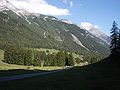
To the east of the Calanda
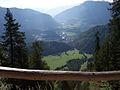
View from the south of the southern Tamina valley
View from the Kunkelspass street to Tamins

Vättis, main town in the middle Tamina valley


Web links
- Franz Xaver Bishop: Pfäfers (community). In: Historical Lexicon of Switzerland .
- Jakob Kuratli Hüeblin: Valens. In: Historical Lexicon of Switzerland .
- Daniel Speaker: Vättis. In: Historical Lexicon of Switzerland .
- Regula Anna Steinhauser-Zimmermann: Drachenloch. In: Historical Lexicon of Switzerland .
- Jürg Simonett: Kunkelspass. In: Historical Lexicon of Switzerland .
- Pfäfers community
- Valens clinics
- Speleology in the Drachenloch
- Kurverein Vättis: Dragon Hole Museum
Individual evidence
- ↑ The Story of the Dragon Hole. Christian Mettler, 2012, accessed December 14, 2013 .
- ↑ Geopark Sardona: Geo-sites ( Memento of the original from October 12, 2014 in the Internet Archive ) Info: The archive link has been inserted automatically and has not yet been checked. Please check the original and archive link according to the instructions and then remove this notice.
- ↑ Tages-Anzeiger of November 29, 2013: First large wolf pack sighted near Valens
- ↑ Southeastern Switzerland of November 30, 2015: Graubünden and St. Gallen want to shoot two wolves
- ↑ Work awarded for the construction of the Tamina Bridge. on: vilan24.ch , October 15, 2012.