Schnaus
| Schnaus | ||
|---|---|---|
| State : |
|
|
| Canton : |
|
|
| Region : | Surselva | |
| Political community : | Ilanz / Glion | |
| Postal code : | 7130 | |
| former BFS no. : | 3583 | |
| Coordinates : | 732 962 / 182085 | |
| Height : | 720 m above sea level M. | |
| Area : | 2.97 km² | |
| Residents: | 123 (December 31, 2013) | |
| Population density : | 41 inhabitants per km² | |
| Website: | www.ilanz-glion.ch/fraktionen/schnaus.html | |
|
Schnaus |
||
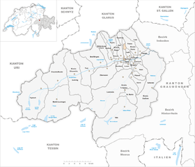
| map | ||
|
|
||
Schnaus ( ) was until December 31, 2013 a political municipality in what was then the Ilanz district in the Surselva district of the canton of Graubünden in Switzerland . On January 1, 2014 Schnaus merged with the former municipalities of Castrisch , Duvin , Ilanz , Ladir , Luven , Pigniu , Pitasch , Riein , Rueun , Ruschein , Sevgein , Siat to form the new municipality of Ilanz / Glion .
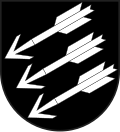
coat of arms
Blazon : Three silver (white) arrows placed obliquely to the left in black
The arrow points to St. Sebastian , to whom the local church was originally dedicated. The three number of arrows stands for the historical community of Schnaus with Ruschein and Ladir .
geography
The community is located on the left side of the Vorderrhein, west of Ilanz . It consists of two parts. The lower southern part extends from the Vorderrhein up to Mulin and extends from 700 m to an altitude of 1220 m. The upper northern part, the Alp da Schnaus, stretches from 1700 m up to the Crest da Tiarms (2412 m above sea level) and consists largely of mountains and forest. The two parts are separated by a strip of the municipality of Ruschein.
Of the entire municipal area of 299 hectares, 174 hectares can be used for agriculture. 144 hectares of this area are alpine pastures . In addition, 92 hectares are covered by forest and wood and 26 hectares are unproductive areas (mountains). The remaining seven hectares are settlement areas.
population
| Population development | |||||||
|---|---|---|---|---|---|---|---|
| year | 1850 | 1900 | 1950 | 1990 | 2000 | 2004 | 2013 |
| Residents | 126 | 123 | 134 | 79 | 99 | 121 | 123 |
Of the 121 residents at the end of 2004, 102 (= 84.30%) were Swiss citizens. The majority of the population speaks Sursilvan and is reformed.
Attractions
The reformed village church is a listed building . The historical Mulin workshop in the west of the village is also of historical importance . On the other side of the brook, but already in the municipality of Rueun, is the chapel of St. Maria Magdalena .
literature
- The municipalities of the canton of Graubünden. Rüegger, Chur / Zurich 2003, ISBN 3-7253-0741-5 .
- Martin Bundi: Schnaus. In: Historical Lexicon of Switzerland . 2016 .


