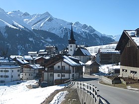
Vignogn
| Vignogn | ||
|---|---|---|
| State : |
|
|
| Canton : |
|
|
| Region : | Surselva | |
| Political community : | Lumnezia | |
| Postal code : | 7147 | |
| former BFS no. : | 3604 | |
| Coordinates : | 731 112 / 173 297 | |
| Height : | 1239 m above sea level M. | |
| Area : | 7.90 km² | |
| Residents: | 154 (December 31, 2012) | |
| Population density : | 19 inhabitants per km² | |
| Website: | www.lumnezia.ch | |
|
Vignogn |
||
| map | ||
|
|
||
Vignogn ( , German and officially Vigens until 1983 ) was until December 31, 2012 a political municipality in the valley of Val Lumnezia in the Surselva district of the canton of Graubünden in Switzerland .
On January 1, 2013, it merged with the municipalities of Cumbel , Degen , Lumbrein , Morissen , Suraua , Vella and Vrin to form the new municipality of Lumnezia .
coat of arms
Blazon : Two golden grapes in red over a golden (yellow) chalice
The grapes and the chalice are the attributes of St. Florinus von Remüs .
geography
The Haufendorf is a hillside settlement on the eastern slope of Piz Sezner (2309 m above sea level) and extends from this down to Glenner (920 m above sea level). Outside the village center there are some single farms that are inhabited all year round. Of the entire former municipal area of 791 ha, only 247 ha were forested and 68 ha were mountain. In addition to 21 ha of settlement area, there is 455 ha of arable land. Cultivated land is only used seasonally in mountain locations. Around 331 hectares are cultivated on the Maiensässen up to the Alplage (Alp Sezner). The favorable location in the Val Lumnezia and the relatively mild climate in a sheltered valley have had a positive influence on the development of the village. The mountain farming village is conveniently located on the main traffic axis of the valley.
The population seems to have originally belonged to the Lepontier tribe , which was based in Ticino, among other places, and reached the Lugnez via the Greinapass. At the end of the 20th century, the majority of the population active in mountain agriculture was around 200 people. Until then, there were always periods of heavy emigration, including to the economically strong Swiss Central Plateau or to America. An overall improvement of the heavily subdivided agricultural goods was started in 1968 and lasted around twenty years. Grain cultivation and self-sufficiency then gave way to extensive cattle breeding and subsidized dairy farming.
Small businesses, the construction of second homes and tourism have strongly shaped the employment structure of the residents in modern times. Around 1985 the former municipality was only able to survive as an autonomous political unit thanks to the cantonal financial equalization scheme (Switzerland) and thanks to sponsorship communities. The commuter distance to the regional center Ilanz / Glion also offers employment opportunities. The alpine villagescape and the hiking trails in the natural Maiensäss landscape are attractive recreational areas for tourism today.
history
The place emerged from an early medieval royal estate. In the early Middle Ages, Vignun was a royal estate and in the High Middle Ages the seat of the Ministeriale de Viggun, from which the name of the village is derived. Around 1170 these are mentioned as episcopal fiefs. They also owned goods in neighboring Surcasti . The two churches of St. Florin and St. Gaudenz already existed around 1345. The latter is a burial church and was rebuilt in 1648 because of a landslide. In 1538 the residents of the diocese of Chur bought themselves out . Vignogn was an independent church until 1697, when it belonged to the Pleif parish in Vella. Politically and culturally, the history of the small mountain community coincides with that of the other Lugnez villages.
population
| Population development | |||||||
|---|---|---|---|---|---|---|---|
| year | 1850 | 1900 | 1950 | 2000 | 2012 | ||
| Residents | 199 | 134 | 204 | 179 | 154 | ||
The main language for 89% of the population is Romansh , 10% stated that they speak better German. All of the 187 residents at the end of 2004 were Swiss citizens.
politics
The former autonomous municipal council consisted of five people. The merger with neighboring communities at the beginning of 2013 brought about by cantonal efforts resulted in a changed political structure in the valley, which is predominantly dominated by the Christian CVP.
traffic
The former municipality is connected to the public transport network by the Ilanz - Vrin and Ilanz - Vignogn postbus lines. The main valley road Ilanz - Vrin is continuously being expanded and offers car traffic good year-round road connections to all villages in the Val Lumnezia.
education
The children from Vignogn in Vella attend kindergarten and the first two classes. Classes from 3rd to 6th grade take place in Cuschnaus (Morissen municipality). Then it goes back to Vella for the school years 7 to 9 at the Lumnezia high school. The school language is Romansh (Idiom Sursilvan ), and German at secondary school. The former village schoolhouse was converted into a holiday accommodation called "Sentupada" by the Vrin architect Gion A. Caminada and is now used as a recreation, education and meeting center for school classes and clubs.
Personalities
- Carmen Casanova , ski racer (* 1980)
- Christian Foppa (1880–1973), politician (KVP)
Attractions
Catholic Parish Church of St. Florinus
literature
- The municipalities of the canton of Graubünden. Chur / Zurich, 2003. ISBN 3-7253-0741-5
- Adolf Collenberg: Vignogn. In: Historical Lexicon of Switzerland . 2016 .
- Zeller Willy. Art and culture in Graubünden. Publishing house Paul Haupt, Bern. 1972


