Siat
| Siat | ||
|---|---|---|
| State : |
|
|
| Canton : |
|
|
| Region : | Surselva | |
| Political community : | Ilanz / Glion | |
| Postal code : | 7157 | |
| former BFS no. : | 3615 | |
| Coordinates : | 731 571 / 183759 | |
| Height : | 1296 m above sea level M. | |
| Area : | 13.53 km² | |
| Residents: | 178 (December 31, 2013) | |
| Population density : | 13 inhabitants per km² | |
| Website: | www.ilanz-glion.ch/fraktionen/siat.html | |
|
Siat |
||
| map | ||
|
|
||
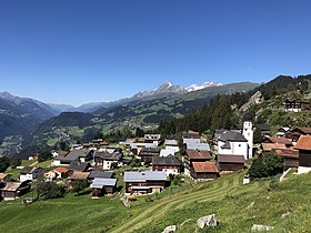
Until December 31, 2013, Siat ( , German Seth ) was a political municipality in the former Ruis district , in the Surselva district of the canton of Graubünden in Switzerland . Of the 193 residents at the end of 2004, 191 were Swiss nationals. On January 1, 2014, Siat merged with the former municipalities of Castrisch , Duvin , Ilanz , Ladir , Luven , Pigniu , Pitasch , Riein , Rueun , Ruschein , Schnaus and Sevgein to form the new municipality of Ilanz / Glion .
coat of arms
Blazon : a seven- pointed golden star in blue over a golden chalice
The chalice stands for St. Florinus, the local church patron ; the seven-pointed star symbolizes the Rhaeto-Romanic name of the community, which means seven.
geography
The cluster village lies on a terrace high above the left bank of the Vorderrhein . The community extends from 930 m above sea level. M. north of Rueun and Schnaus up to an altitude of 2833 m near the Vorab on the border with the canton of Glarus. Of the entire municipal area of 1348 ha, 689 ha are agriculturally usable, 565 ha of which are Maiensässen. 453 hectares of the municipal area are covered by forest and wood and 180 hectares of unproductive area (mountains). The remaining 26 hectares are settlement areas.
The Senda Sursilvana , a long-distance hiking trail along the young Rhine, leads from the Oberalp Pass through Siat towards Chur.
population
| Population development | |||||||
|---|---|---|---|---|---|---|---|
| year | 1803 | 1850 | 1900 | 1950 | 1960 | 2000 | 2013 |
| Residents | 203 | 239 | 185 | 219 | 241 | 189 | 178 |
Attractions
- The St. Lucius Church on a hill in the east of the village was built in 1656. The wall paintings in the choir are by Hans Ardüser .
- Above the village are the ruins of Friberg Castle from the beginning of the 13th century.
- In December 2010 the Ustria Steila , a building by the Bünder architect Gion A. Caminada, opened in the middle of the village .
Castle hill with the ruins of Friberg Castle
literature
- The municipalities of the canton of Graubünden. Chur / Zurich, 2003. ISBN 3-7253-0741-5
- Adolf Collenberg: Siat. In: Historical Lexicon of Switzerland . 2016 .
Web links
Individual evidence
- ↑ Hiking Switzerland on the Senda Sursilvana in Graubünden
- ↑ Church of St. Luzius on www.graubuendenkultur.ch .


