
In advance
| Bündner Vorab | ||
|---|---|---|
 Advance area from the northeast; to the far left of the cloud covered Vorab Pign, the highest point on the horizon is the Bündner Vorab, to the right by the Vorabsattel separated from the Glarner Vorab. The Tödi can be seen behind this saddle. |
||
| height | 3028 m above sea level M. | |
| location | Border canton Glarus / Canton Graubünden , Switzerland | |
| Mountains | Glarus Alps | |
| Dominance | 6.7 km → Hausstock | |
| Notch height | 418 m ↓ Bündnerbergjoch | |
| Coordinates | 730 968 / 192842 | |
|
||
| particularities | Mountain landing pad for helicopters on the Glarner Vorab, for fixed-wing aircraft on the glacier | |
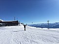
 Double ski lift on the Vorab glacier. Center of the Bündner, on the right the Glarner Vorab, on the left the Vorbipfel Vorab Pign |
||
 Bündner Vorab and Vorab Pign as seen from Piz Grisch in autumn 1960 |
||

The advance , 3028 m above sea level. M. , is a mountain in Switzerland with the main summit Bündner Vorab and the secondary summit Glarner Vorab 3018 m , both on the border of the cantons of Glarus and Graubünden . The main peaks are in the municipal area of Elm , Siat and Laax . The municipalities Falera and Panix also join the area with the secondary peaks . From the settlement area of the adjoining places, the mountain can only be seen from Elm in its steep north flank or just barely from Flims-Waldhaus, as its south-east to south-west flanks and ridges fall very gently.
Surname
The name is probably explained by the Glarus people, according to which the mountain, as a visible border marker, is directly "in front of" the canton border and sloping away very elongated and flat towards the south ("abe" in dialect).
Summit of the advance
Another nearby summit, the Vorab Pign (small Vorab; 2897 m ), is located 500 m to the east exclusively in Graubünden. A chair lift led into the saddle between the Bündner Vorab and the Vorab Pign for a few years, but was demolished before 1995.
Interestingly, the border between the Graubünden and Glarner Vorab does not run on the watershed, but as a straight line. This may be due to the fact that in earlier years the glacier was more extensive and at least part of the border was always covered with snow. On the Vorabfirn moving east, the border naturally also runs as a straight line. To the north of the border in the Glarus area is the Gletscherhorn with a peak of 2805 m . To the north of this are the striking towers of the Zwölfihorn ( 2744 m / 2741 m ), from where a side ridge leads to the Chli Mittagshorn ( 2369 m ), whereas the named Madgrat slopes down to the Mittagshorn ( 2415 m ).
To the east of this is the Martinsmadhütte at 2002 m , from which you can reach the high plateau of the Vorabfirn on a blue and white marked high alpine path through the Schwarzwändli. In a west-southwest direction, a ridge leads from the Bündner Vorab over many nameless listed high points to the Panixer Pass , which connects Elm in the canton of Glarus with Panix in the canton of Graubünden. Only two points have a name here: On the one hand, the Rotstock / Crap Tgietschen ( 2624 m ) towering over the Panixerpass, which just about reaches the definition of a mountain peak, and the Crena Martin ( 2727 m ), which could probably be used as a crossing for sheep ; the highest grass fields on the Glarus side of the border were inaccessible from the north.
Another mountain ridge to the southeast must also be added to the Vorab, it runs first over the Vorab Pign to Fuorcla di Sagogn and there past Crap Masegn in the direction of Crap Sogn Gion .
The Vorab glacier is located in the eastern hollow , and the highest high-voltage power line in Europe, the Vorablerung, runs even further to the east .
Development as a ski area
In 1978/79, the Vorab glacier was made accessible for alpine skiers with a double drag lift anchored in the ice. The hoped-for summer operation was discontinued around 1991, but the area allows a guaranteed season opening for winter operation in November even before artificial snow-making. This is in contrast to other ski areas, which sometimes have to postpone the start of the season. Before and in the future, flights with helicopters were possible in advance, for example from the Crap Sogn Gion, as the glacier is open as a mountain landing site (helicopters land on the Glarner Vorab). With a bit of luck, you might catch a day on which a glacier plane offers sightseeing flights at the edge of the piste (this has become increasingly rare in recent years).
Mountain station in advance

Bündner Vorab from the north, seen from a little below the terminus of the ski lifts
Northern flank of the Glarner Vorab with Gletscherhorn and Zwölfihorn in the foreground, Elm GL is located in the valley floor

Northern flank of the Glarner Vorab

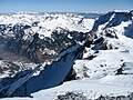
The Bündner Vorab (center of the picture) is hardly visible from Flims, in contrast to the steeply rising Glarus side. Here, on the left, its branch Crap Sogn Gion moves into the foreground.


Web links
- In advance on the ETHorama platform
Individual evidence
- ↑ National map 1: 25,000 Elm, number 1174.
- ↑ Flims Laax Falera ski area. In: Bergfex. Retrieved March 11, 2015 .
- ↑ Davos without the possibility to open the season early