Engstlensee
| Engstlensee | ||
|---|---|---|

|
||
| Engstlensee | ||
| Geographical location | Bernese Oberland | |
| Tributaries | various mountain streams | |
| Drain | Gental water | |
| Places on the shore | Engstlenalp | |
| Data | ||
| Coordinates | 670138 / 180588 | |
|
|
||
| Altitude above sea level | 1850.8 m above sea level M. | |
| surface | 44 ha | |
| length | 1.3 km | |
| width | 600 m | |
| volume | 2,000,000 m³ | |
| Maximum depth | 49 m | |
|
particularities |
||

|
||
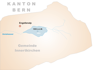
The Engstlensee is a natural lake on the Engstlenalp in the canton of Bern in Switzerland , which is used as a storage lake by the Oberhasli (KWO) power plants through an underground lake .
location
The lake is at around 1851 m above sea level. M. at the upper end of the Gental in the Susten area on the Jochpass ( 2207 m ) near the borders with the cantons of Nidwalden and Obwalden at the foot of the Titlis ( 3238 m above sea level ), the highest peak in the region.
Surroundings
The Engstlensee is a popular destination, especially because of its close proximity to the Titlis. It can be reached from Engelberg by cable car or on foot and is often combined in a tour with the Trüebsee , Tannensee and Melchsee - three similarly large lakes in the region that can be hiked from Engelberg and then again from Melchsee-Frutt to get into the valley.
use
The mountain lake , rich in fish, has a volume of around 10.7 million m³, of which one million m³ is used by the KWO for generating electricity. The lake has an underground lakeshore that makes it possible to lower the lake by five meters in winter. The inlet structure of the 600 m long drainage tunnel is on the right. The tunnel flows into the Gäntalwasser ⊙ about 250 m below the natural lake outflow ⊙ , which is collected after another 480 m ⊙ and is led through a tunnel into the neighboring Gadmertal . There it is used by the Fuhren power plant, which directs its underwater water through a counterpressure tunnel into the Schaftelen tunnel window of the Steinwasser – Trift inlet tunnel. The water can then either be used in the Hopflauenen and Innertkirchen 2 power plants or pumped into the Räterichsboden reservoir via the pump turbine from Handeck 3 .
Web links
Individual evidence
- ↑ The expansion of hydropower in the Gental and Gadmental with the Fuhren power station . In: Schweizerische Bauzeitung . tape 79 , no. 44 , November 2, 1961, pp. 755 , doi : 10.5169 / seals-65615 .
- ↑ Reservoirs. In: Grimselstrom. KWO, accessed on May 17, 2020 (Swiss Standard German).
- ↑ Plant diagram of the KWO.
- ↑ Central sheets Fuhren (Gental) and Fuhren (pump center) . In: Statistics on hydropower plants in Switzerland. Federal Office of Energy, January 1, 2020 .
- ↑ The expansion of hydropower in the Gental and Gadmental with the Fuhren power station . In: Schweizerische Bauzeitung . tape 79 , no. 44 , November 2, 1961, pp. 755 , doi : 10.5169 / seals-65615 .
