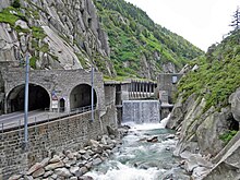
Urnerloch
The Urnerloch near Andermatt in the canton of Uri is the first Swiss traffic tunnel and one of the oldest tunnels on a traffic route through the Alps. It connects the southern end of the Schöllenen Gorge with the Urserental and is part of the route over the Gotthard Pass .
The tunnel has been continuously expanded over the centuries. Today Hauptstrasse 2 runs through it. It lies at an altitude of around 1430 m above sea level. M. Today it is around 70 meters long - in front south but is a more than 300-meter-long protection gallery .
history

The Urnerloch was built by Pietro Morettini in 1707 and 1708 and replaced the Twärrenbrücke , a wooden walkway hanging on the wall of the Chilchbergfelsen in the Schöllenen Gorge along the Reuss . This "floating footbridge" along the rock face was repeatedly destroyed by the floods of the Reuss.
The tunnel was 64 meters long, unlit and “just high enough that the pack animals could find a passage without a rider”. The construction of the tunnel with gunpowder had only taken eleven months, but it was significantly more expensive than planned.
The first expansion took place with the construction of the road over the Gotthard, which was opened in 1830. With the construction of the motorway in 1954, the tunnel was expanded again. Later, a 300 meter long protective gallery was built on the south side of the tunnel. In 2014 the tunnel was repaired and expanded again.
The track of the Schöllenenbahn , opened in 1917, was laid in the gorge parallel to the tunnel along the rock face and later protected by a gallery over which a hiking trail leads.
literature
- Georg Anagnostou, Heinz Ehrbar (Eds.): Tunneling Switzerland. VDF, Zurich 2013, ISBN 978-3-7281-3547-6
- Alois Müller: The Urnerloch. From the Thalbuche v. Mr. Thalammann Johann Seb. Schmid. In: The history friend. Announcements of the Central Switzerland Historical Association , 1887 (42), pages 244–250.
Web links
- Urnerloch on the ETHorama platform
Individual evidence
- ^ Hans Grob: Tunnel. In: Historical Lexicon of Switzerland . January 7, 2014 , accessed February 16, 2020 .
- ↑ The Buco di Viso from the 15th century in the Cottian Alps is certainly older .
- ↑ Information on the road sign at the tunnel entrance, cf. File: Street sign at the Urnerloch.jpg .
- ↑ a b Alfred Hagmann, Urs Steifer: The developments of the mule tracks: Urner traffic routes across the Alps . In: Swiss engineer and architect . tape 110 , issue 17/18, 1992, p. 344-348 , doi : 10.5169 / seals-77894 .
- ↑ Switzerland is the land of tunnels. In: Tecmania.ch. Swissmem, 2012, archived from the original on July 7, 2015 ; Retrieved July 7, 2015 .
- ^ EP Schöllenen - Repair of the Urnerloch Tunnel. (PDF) In: Lazzarini. Retrieved January 5, 2016 .
Coordinates: 46 ° 38 '43.3 " N , 8 ° 35' 27.1" E ; CH1903: 688 211 / 166659

