
Col de l'Iseran
| Col de l'Iseran | |||
|---|---|---|---|
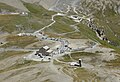
 View of the summit of the Col de l'Iseran from the parking lot higher up (June 2005), behind it the Pointe des Lessières , 3041 m |
|||
| Compass direction | North side | South side | |
| Pass height | 2764 m | ||
| Department | Savoie , France | ||
| Valley locations | Bourg-Saint-Maurice | Bonneval-sur-Arc | |
| expansion | Pass road (D902) | ||
| Built | 1936 | ||
| Winter closure | October 1st - May 30th | ||
| Mountains | Graian Alps | ||
| profile | |||
| Mountain scoring | 1 | 1 | |
| Ø pitch | 4.1% (1955 m / 48 km) | 7.5% (977 m / 13 km) | |
| Max. Incline | (at km 7) | (at km 10) | |
| Map (Savoie) | |||
|
|||
| Coordinates | 45 ° 25 ′ 1 ″ N , 7 ° 1 ′ 51 ″ E | ||

The Col de l'Iseran is with a height of 2,764 m , the highest traversable mountain pass of the Alps - the Col de la Bonette is 2,715 m high, the 2,802 m can only be achieved by the additional loop , but is not a pass.
location
The pass is located in the French department of Savoie . The continuously paved road is part of the Route des Grandes Alpes . It connects the high valleys of the Isère ( Tarentaise ) and the Arc ( Maurienne ).
The actual pass road runs from Val-d'Isère in the north to Bonneval-sur-Arc in the south. On the north side in particular, the well-developed preceding ascent from Seéz to Val-d'Isère almost always has the character of a pass road with gradients between seven and twelve percent ( SG 2 ).
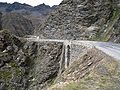
On the north side there are well-known winter sports resorts such as Tignes and Val-d'Isère, along the reservoir near Tignes the road leads through a long series of galleries and tunnels, while the south side is exposed through a barren high valley.
The road is only passable in summer; in winter it is used as part of a ski slope in the Espace Killy ski area .
Directly west of the top of the pass is the Pointe des Lessières , a relatively easy three-thousand-meter peak with a height of 3,041 m and an impressive view of the pass road.
Départementstrasse 902 (the former Route nationale 202 ) runs over the pass . Both climbs are equipped with special signs for cyclists .
Tour de France
The Col de l'Iseran has been on the Tour de France program eight times , most recently in the Tour de France 2019 , before that in 1938 , 1939 , 1949 , 1963 , 1992 and 2007 . In 1996 it was also on the program, but the crossing was canceled at short notice due to bad weather. In 2019 it will be crossed on the 19th stage , the first driver will also receive the souvenir Henri Desgrange .

View over the pass road in west direction

Chapel with statue by Edgar Delvaux
View of the top of the pass
South side

The last special milestone for cyclists on the climb from Bonneval-sur-Arc
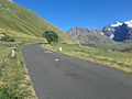
View of the pass road in the ascent from Bonneval-sur-Arc 8 km before the summit at 2150 m altitude


See also
literature
- Road bike guide: Kristian Bauer: Roadbook Tour de France. Conquer 40 top climbs from the Alps to the Pyrenees on your own racing bike. (Plus highlights from the history of the tour). Bruckmann, Munich 2006, ISBN 3-7654-4477-4 .
- History: Peter Leissl : The legendary climbs of the Tour de France. Covadonga, Bielefeld 2004, ISBN 3-936973-09-1 .
- Photo book: Serge Laget: Cols mythiques du Tour de France. L'Equipe, Issy-Les-Moulineaux 2005, ISBN 2-915535-09-4 .
Web links
- 4biker.eu
- Slope profile of the north side
- Slope profile of the south side
- GPS track, map, elevation profile on alpenrouten.de
Individual evidence
- ↑ Kurt Mair: The elevated roads of the Alps . 9th edition; Richard Carl Schmidt & Co Braunschweig 1965, ISBN 3-901182-36-5 , p. 462
Agnel • Allos • Andrion • Aravis • Bonette • Braus • Cayolle • Champs • Colle-Saint-Michel • Colombière • Croix de Fer • Croix-Fry • Cuillole • Galibier • Gets • Glandon • Granon • Iseran • Izoard • Jambaz • Joux Plane • Joux Verte • Larche • Lautaret • Lebraut • Lombarde • Madeleine • Saint Martin • Méraillet • Mollard • Mont Cenis • Montets • Montgenèvre • Morgins • Moutière • Ornon • Pré • Petit Saint-Bernard • Pontis • Ramaz • Roselend • Rousset • Saisies • Télégraphe • Tende • Turini • Valberg • Vars