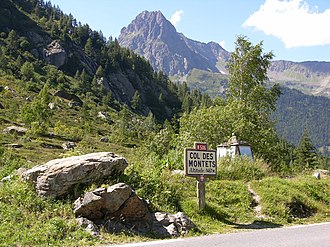
Col des Montets
| Col des Montets | |||
|---|---|---|---|
|
Col des Montets |
|||
| Compass direction | Northeast | southwest | |
| Pass height | 1461 m | ||
| Department | Haute-Savoie | Haute-Savoie | |
| Valley locations | Vallorcine | Chamonix | |
| expansion | D 1506 / railway tunnel | ||
| Winter closure | No | ||
| Mountains | French Alps | ||
| particularities | If the pass is closed in winter, use of the railway tunnel as a road | ||
| map | |||
|
|
|||
| Coordinates | 46 ° 0 '13 " N , 6 ° 55' 24" E | ||
The Col des Montets is a 1,461 m high pass in the French Alps , which connects the Arve valley and the local capital Chamonix with the Swiss canton of Valais .
Pass height
At the top of the pass there is an information center for the nature reserve of the Aiguilles Rouges with a botanical information trail. The 46th parallel is not far from the pass. It is marked with a small plaque.
Traffic connection
The pass connects the Swiss town of Martigny with Chamonix , although on the Swiss side the Col de la Forclaz still has to be crossed. The Saint-Gervais – Vallorcine railway crosses under the pass in a 1883 m long tunnel. The road D 1506 (until 2006 the RN 506) runs over the pass. The pass is usually open in winter, but it is closed due to the weather, but vehicles can then use the railway tunnel, which has been equipped with a concrete lane next to the track. The traffic is then regulated by a control system, and the trains only run from and to Montroc on the French side (instead of Vallorcine on the Swiss side).

