
Col des Aravis
| Col des Aravis | |||
|---|---|---|---|
.JPG) Col des Aravis pass |
|||
| Compass direction | Northwest | South / east | |
| Pass height | 1486 m | ||
| Department | Haute-Savoie | Savoy | |
| Watershed | Vallée du Fier | Val d'Arly | |
| Valley locations | Saint-Jean-de-Sixt | Flumet | |
| expansion | Pass road (asphalted) | ||
| Mountains | Aravis mountain range | ||
| profile | |||
| Ø pitch | 4.6% (527 m / 10.4 km) | 5.0% (580 m / 11.5 km) | |
| Max. Incline | 8th % | 11% | |
| Map (Haute-Savoie) | |||
|
|||
| Coordinates | 45 ° 52 '21 " N , 6 ° 27' 53" E | ||

The Col des Aravis is a pass over the Aravis mountain range in the French Prealps. The north-western part of the pass road is in the Haute-Savoie ( Haute-Savoie ) department and the south-eastern part in the Savoie (Savoy) department. The D909 road leads over the pass and is not always kept open in winter. It connects the two cities of Annecy and Chamonix . On the western side not far from the top of the pass is the winter sports resort La Clusaz and on the other side in the east the winter sports resort La Giettaz . The Tour de France went over the pass repeatedly. The pass road is part of the Route des Grandes Alpes , which leads from Lake Geneva over 16 passes in the French Alps to the Mediterranean .
description
The Col des Aravis is the lowest pass in the Aravis mountain range. The increase is moderate on both sides with an average of around 5.0%. At the top, the gradient on the southeast approach from Flumet is 11% and 8% on the opposite side. The pass is popular with car tourists, motorcyclists and cyclists during the holiday season. The view of the Mont Blanc massif to the east of the pass is impressive .
Tour de France
As of 2019, the pass had already been part of the Tour de France forty times , seventeen of them since 1947. After the Col du Galibier , it is the second most popular pass in the Alps. In the mountain classification it is considered the second category. Its popularity does not come primarily from its degree of difficulty, but from its location as an approach combined with a mountain route on the way to the demanding passes of the Savoy Alps .

Switchbacks on the northwest side

Last climb from the northwest
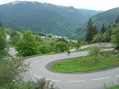
Ascent from the southeast with many hairpin bends
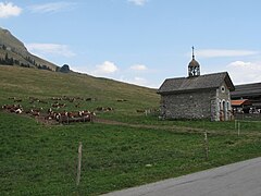
Aravis Chapel at the top of the pass


Web links
Individual evidence
- ↑ Le col des Aravis dans le Tour de France depuis 1947 ( fr ) In: le dico du tour . Retrieved July 29, 2019.
- ^ Col des Aravis / Route des Grandes Alpes . In: Alpine routes . Accessed July 31, 2019.
- ↑ Col des Aravis (1486 m) . In: quaeldich.de . Accessed July 31, 2019.
Agnel • Allos • Andrion • Aravis • Bonette • Braus • Cayolle • Champs • Colle-Saint-Michel • Colombière • Croix de Fer • Croix-Fry • Cuillole • Galibier • Gets • Glandon • Granon • Iseran • Izoard • Jambaz • Joux Plane • Joux Verte • Larche • Lautaret • Lebraut • Lombarde • Madeleine • Saint Martin • Méraillet • Mollard • Mont Cenis • Montets • Montgenèvre • Morgins • Moutière • Ornon • Pré • Petit Saint-Bernard • Pontis • Ramaz • Roselend • Rousset • Saisies • Télégraphe • Tende • Turini • Valberg • Vars