Col du Telegraphe
| Col du Telegraphe | |||
|---|---|---|---|
|
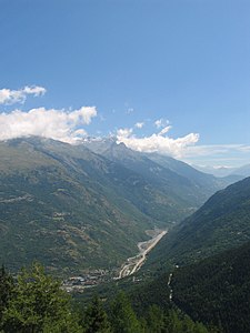
View from the pass into the Arctal, down to the right in the forest the pass road |
|||
| Compass direction | North side | South side | |
| Pass height | 1566 m | ||
| Department | Savoie , France | ||
| Valley locations | Saint-Michel-de-Maurienne | Valloire | |
| expansion | D 902 | ||
| Mountains | french alps | ||
| profile | |||
| Mountain scoring | 1 | 4th | |
| Ø pitch | 7.1% (854 m / 12 km) | 2.7% (136 m / 5 km) | |
| Max. Incline | 7.4% (on km 8) | 2.7% (on km 5) | |
| map | |||
|
|
|||
| Coordinates | 45 ° 12 '9 " N , 6 ° 26' 40" E | ||
The Col du Télégraphe is a mountain pass with a height of 1566 m in the French Alps , department Savoie . The well-developed, paved road connects the resort of Valloire with Saint-Michel-de-Maurienne in the Arc Valley in the Maurienne area.
The pass gets its name from the fort on a rocky promontory near the pass.
The pass is best known for its frequent crossings as part of the Tour de France . To drive on the north side of the Col du Galibier , the Télégraphe must first be conquered. This difficult combination usually makes this part of the day the “queen's stage”. Most racing drivers still save their energy on this mountain, which is why attacks rarely occur here.
The climb of Saint-Michel-de-Maurienne is equipped with special milestones for cyclists every one kilometer . In the middle section these stones are missing here and there.


