
Milestones on mountain passes for cyclists
Milestones on mountain passes are specific milestones that cyclists about their current position with respect to the pass check. They basically give information in the direction of travel of the summit . In some cases the lettering is on both sides and thus also informs cyclists who are traveling downhill. Milestones on mountain passes are particularly helpful for cyclists who do not know the route. In general, they help cyclists plan rest breaks or allocate drinks and food. From the point of view of the institutions that put up these signs, for example the general councils of the departments in France, is an investment to promote cycle tourism .
Type of information
Milestones on mountain passes always contain a pictogram of a bicycle or cyclist as well as the following standard information:
- Name of the mountain pass
- height
- Distance to the top of the pass
- Average incline in the following part of the ascent
Depending on the mountain pass, additional information can be found such as:
- Name and / or emblem of the responsible institution
- Street number
- Height of the mountain pass
- Distance to villages or towns near the pass
- Distance covered since the start of the climb
Usually these markings are set up at a distance of one kilometer. The specified mean gradient then relates to the next kilometer.
France
Milestones can be found along very many mountain passes in the French Pyrenees and Alps . Their design is often based on traditional French milestones (white block with yellow top).
Mountain passes with milestones
The table below lists passes that are known to have milestones for cyclists. If a pass is not included, it does not mean that it is not marked in this way. All milestones show the standard information. The table also shows the accuracy of the slope. Additional information and emblems (if any) are explained in the Comment column.
| Surname | height | country | Accuracy of the slope | Example and date | comment |
|---|---|---|---|---|---|
| Cime de la Bonette just above the Col de la Bonette from Jausiers | 2802 m | France | 0.1% |
 Summer 2014 Summer 2014 |
Emblem on the left: Similar to that of Jausiers ; Emblem on the right: Provence-Alpes-Côte d'Azur ; C1: number of the country road; 2: Distance from the start in Jausiers. |
| Cime de la Bonette just above the Col de la Bonette to Jausiers Here: Information for descents | 2802 m | France | 0.1% |
 Summer 2014 Summer 2014 |
Emblem on the left: Similar to that of Jausiers ; Emblem on the right: Provence-Alpes-Côte d'Azur ; C1: number of the country road; 2: Distance from the start in Jausiers. |
| Cime de la Bonette just above the Col de la Bonette of Saint-Étienne-de-Tinée | 2802 m | France | 1 % |
 Summer 2014 Summer 2014
|
Emblem on the left: Métropole Nice Côte d'Azur ; Emblem on the right: Mercantour National Park ; M2205: street number; 77: Distance to the starting point of this country road. |
| Cime de la Bonette just above the Col de la Bonette to Saint-Étienne-de-Tinée Here: Information for descents | 2802 m | France | 1 % |
 Summer 2014 Summer 2014
|
Emblem on the left: Métropole Nice Côte d'Azur ; Emblem on the right: Mercantour National Park ; M2205: street number; bold 77: Distance to the starting point of this country road. |
| Col de l'Iseran from Val-d'Isère | 2770 m | France | 1 % |
 Summer 2015 Summer 2015 |
On the side is the Savoie emblem and the number of the country road (D 902). |
| Col de l'Iseran from Bonneval-sur-Arc | 2770 m | France | 1 % |
 Summer 2015 Summer 2015 |
On the side is the Savoie emblem and the number of the country road (D 902). |
| Col Agnel of Château-Queyras | 2744 m | France | 0.1% |
 Summer 2014 Summer 2014 |
Emblem: Conseil général Hautes Alpes ; 2744 m: height of the mountain pass; There is a QR code in the lower right corner . |
| Col du Galibier of Valloire | 2642 m | France | 1 % |
 Summer 2015 Summer 2015 |
On the side is the Savoie emblem and the number of the country road (D 902). |
| Col du Galibier from Col du Lautaret | 2642 m | France | 0.1% |
 Summer 2015 Summer 2015 |
Emblem: Conseil général Hautes Alpes ; 2642 m: height of the mountain pass; There is a QR code in the lower right corner . A number of signs are missing from this climb (July 2015). |
| Col d'Izoard by Briançon | 2360 m | France | 0.1% |
 Summer 2014 Summer 2014 |
Emblem: Conseil général Hautes Alpes ; 2360 m: height of the mountain pass; There is a QR code in the lower right corner . |
| Col d'Izoard by Guillestre | 2360 m | France | 0.1% |
 Summer 2014 Summer 2014 |
Emblem: Conseil général Hautes Alpes ; 2360 m: height of the mountain pass; There is a QR code in the lower right corner . |
| Col de la Cayolle by Barcelonnette | 2326 m | France | 1 % |
 Summer 2014 Summer 2014 |
Emblem: Conseil général Alpes-de-Haute-Provence ; D902: street number. |
| Col d'Allos by Barcelonnette | 2250 m | France | 1 % |
 Summer 2014 Summer 2014 |
Emblem: Conseil général Alpes-de-Haute-Provence ; D908: street number. |
| Col d'Allos from Colmars | 2250 m | France | 1 % |
 Summer 2015 Summer 2015 |
Emblem: Conseil général Alpes-de-Haute-Provence ; D908: street number. |
| Col du Tourmalet from Sainte-Marie-de-Campan | 2115 m | France | 0.5% |
 Summer 2015 Summer 2015 |
Emblem: Conseil général Hautes-Pyrénées ; 2115 m: height of the mountain pass. |
| Col du Tourmalet from Luz-Saint-Sauveur | 2115 m | France | 0.5% |
 Summer 2015 Summer 2015 |
Emblem: Conseil général Hautes-Pyrénées ; 2115 m: height of the mountain pass. |
| Col de Vars from Guillestre | 2109 m | France | 0.1% |
 Summer 2014 Summer 2014 |
Emblem: Conseil général Hautes Alpes ; 2109 m: height of the mountain pass; There is a QR code in the lower right corner . |
| Col de Vars from Jausiers | 2109 m | France | 1 % |
 Summer 2014 Summer 2014 |
Emblem: Conseil général Alpes-de-Haute-Provence ; D902: street number. |
| Col des Champs of Colmars | 2087 m | France | 1 % |
 Summer 2014 Summer 2014 |
Emblem: Conseil général Alpes-de-Haute-Provence ; D2: street number. |
| Col du Mont Cenis from Lanslebourg-Mont-Cenis | 2083 m | France | 1 % |
 Summer 2015 Summer 2015 |
On the side is the Savoie emblem and the number of the country road (D 1006). |
| Col de la Croix de Fer of Saint-Jean-de-Maurienne | 2067 m | France | 1 % |
 Summer 2015 Summer 2015 |
On the side is the Savoie emblem and the number of the country road (D 926). |
| Col de la Madeleine by La Léchère | 1993 m | France | 1 % |
 Summer 2011 Summer 2011 |
On the side (not visible in the picture) is the Savoie emblem and the number of the country road (D 213). |
| Col de la Madeleine from La Chambre | 1993 m | France | 1 % |
 Summer 2015 Summer 2015 |
On the side is the Savoie emblem and the number of the country road (D 213). |
| Col du Glandon from La Chambre | 1924 m | France | 1 % |
 Summer 2015 Summer 2015 |
On the side is the Savoie emblem and the number of the country road (D 927). |
| Col de la Couillole of Saint-Sauveur-sur-Tinée Here: information for trips up and down | 1679 m | France | 1 % |
 Summer 2014 Summer 2014 |
M30: street number; 11: Distance to and from the start in Saint-Sauveur-sur-Tinée |
| Col du Mollard by Saint-Jean-de-Maurienne | 1638 m | France | 1 % |
 Summer 2015 Summer 2015 |
On the side is the Savoie emblem and the number of the road (D 110). |
| Peyragudes from the west side of the Col de Peyresourde | 1620 m | France | 0.5% |
 Summer 2015 Summer 2015 |
Emblem: Conseil général Hautes-Pyrénées ; 1620 m: height of the mountain pass. |
| Col de Peyresourde by Armenteule | 1569 m | France | 0.5% |
 Summer 2015 Summer 2015 |
Emblem: Conseil général Hautes-Pyrénées ; 1569 m: height of the mountain pass. |
| Col du Télégraphe of Saint-Michel-de-Maurienne | 1566 m | France | 1 % |
 Summer 2015 Summer 2015 |
On the side is the Savoie emblem and the number of the country road (D 902). |
| Hourquette d'Ancizan by Payolle | 1564 m | France | 0.1% |
 Summer 2015 Summer 2015 |
Emblem: Conseil général Hautes-Pyrénées ; 1564 m: height of the mountain pass. |
| Hourquette d'Ancizan by Ancizan | 1564 m | France | 0.1% |
 Summer 2015 Summer 2015 |
Emblem: Conseil général Hautes-Pyrénées ; 1564 m: height of the mountain pass. |
| Col d'Aspin by Arreau | 1489 m | France | 0.5% |
 Summer 2015 Summer 2015 |
Emblem: Conseil général Hautes-Pyrénées ; 1489 m: height of the mountain pass. |
| Col d'Aspin from Sainte-Marie-de-Campan | 1489 m | France | 0.5% |
 Summer 2015 Summer 2015 |
Emblem: Conseil général Hautes-Pyrénées ; 1489 m: height of the mountain pass. |
Gallery of milestones on mountain passes for cyclists

The last two kilometers of the Col de Peyresourde in the ascent from Armenteule with the penultimate kilometer on the left.
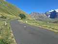
Pass road of the Col de l'Iseran in the ascent from Bonneval-sur-Arc 8 km before the summit at 2150 m altitude with the kilometer stone on the right.

A no longer used design on the Col de l'Iseran .


Individual evidence
- ↑ Cycling - Pra Loup . Valée Ubaye. Retrieved June 13, 2015.
- ↑ Peak Retreats Alpine activities. From road cycling in a variety of resorts such as Samoens, Les Gets, Vaujany, St Sorlin . Peak retreats. Retrieved June 13, 2015.
- ↑ Cyclotourisme et vélo loisir en Ubaye au coeur des Alpes du Sud (in French) . Valée Ubaye. Retrieved June 16, 2015.