
Col du Tourmalet
| Col du Tourmalet | |||
|---|---|---|---|
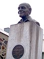
 The top of the pass with the sculpture Géant du Tourmalet . |
|||
| Compass direction | west | east | |
| Pass height | 2115 m | ||
| Department | Hautes-Pyrénées , France | ||
| Valley locations | Luz-Saint-Sauveur | Sainte-Marie-de-Campan | |
| expansion | D 918 | ||
| Winter closure | December – May | ||
| Mountains | Pyrenees | ||
| profile | |||
| Mountain scoring | Hors Catégorie | Hors Catégorie | |
| Ø pitch | 7.6% (1405 m / 18.4 km) | 7.4% (1270 m / 17.1 km) | |
| Max. Incline | 10.2% | 10% | |
| Map (Hautes-Pyrénées) | |||
|
|||
| Coordinates | 42 ° 54 '31 " N , 0 ° 8' 43" E | ||

At 2115 meters above sea level, the Col du Tourmalet is the highest paved road pass in the French Pyrenees . It is located in the Hautes-Pyrénées department and connects Luz-Saint-Sauveur with Campan . The Col du Tourmalet owes its high profile to its central role in the history of the Tour de France and the fact that it is crossed very frequently in the current editions of the Tour. This made the pass a very popular destination for ambitious recreational cyclists. In the winter season the road is hidden under a thick blanket of snow in the middle of a ski area. In the summer season the surrounding pastures are used for livestock.
There are two theories about the origin of the name Tourmalet . The assumption of a Latin ancestry leads to the meaning of bad way , whereas an ancestry from the Gaskognischen language gives distant mountain as an etymology .
Routing
The ascent from the west side starts in Luz-Saint-Sauveur, goes over Barèges and overcomes an altitude difference of 1405 m over 18.4 km with an average gradient of 7.6%. The east approach from Sainte-Marie-de-Campan via La Mongie is 17.1 km long with an average gradient of 7.4% at 1270 meters of altitude to be overcome. Both climbs are equipped with special signs for cyclists at intervals of one kilometer .
At the top of the pass, a 5.5 km long slope branches off to the Pic du Midi de Bigorre , which is closed to normal traffic. Your end point, Col les Laquets, is at an altitude of 2637 m, making it the highest approachable point in the Pyrenees.
Higher roads in the Pyrenees
The Col du Tourmalet is the highest paved road pass in the French Pyrenees. Contrary to frequently read information (see for example) it is neither the highest paved road in the French Pyrenees nor the highest road pass in the French Pyrenees nor the highest paved road pass in the Pyrenees. The paved roads to the mountain lakes Lac de Cap-de-Long and Lac d'Aumar are higher, as these lakes, also located in the Hautes-Pyrénées department , are located at 2161 and 2192 meters above sea level. However, these roads do not meet the criteria of a road pass. The unpaved road to the Col les Laquets pass leads up to 2637 m. The highest paved road pass in the Pyrenees is the Port d'Envalira in Andorra , at 2407 meters above sea level .
Tour de France
The Col du Tourmalet is best known for the Tour de France . In 1910, at the suggestion of Alphonse Steinès from Luxembourg, the pass was the first high mountain pass to be included in the Tour de France program. Back then there was only one path over the pass and there were wild bears in the Pyrenees . While inspecting the pass, Steines almost died, but telegraphed his superior Henri Desgrange the now almost legendary words “ I got over the Tourmalet well. Stop. Road in good condition. Stop. No problems for the drivers. “The eventual overall winner Octave Lapize was the first Tour de France rider to overcome the top of the pass. One increase later, at the Col d'Aubisque , he called the tour organizers a murderer because of the difficulty of the route (" Vous êtes des assassins. Oui, des assassins! "). The drama of Eugène Christophe, mentioned every year by television commentators, and his broken bicycle fork , which he had to repair himself after a long walk in a forge in Sainte-Marie-de-Campan, also occurred at the Tourmalet in 1913.
Today, the Col du Tourmalet, together with L'Alpe d'Huez , the Col du Galibier and the Mont Ventoux, is one of the toughest and most famous climbs of the Tour de France ( Hors Catégorie ) with a special number of points and is crossed almost every year, but now on a well-developed road. At the Tour de France 2010 it was conquered twice to mark the anniversary of the first ascent. The 16th stage (75th ascent) started him via the east ramp, on the 17th stage (76th ascent) he was the second time after 1974 the destination of a mountain arrival . Back then, too, it was part of the course twice. Most recently, the 14th stage of the Tour de France 2019 ended on the Col du Tourmalet.
The Tourmalet is not only the oldest, but also the most frequently traveled high mountain pass in the 106 tours of the tour. In addition to the 79 passages at the culmination point, mountain climbing took place at the top of the pass in 1974, 2010 and 2019 (as of 2019). In 1970, 2002 and 2004 there were mountain arrivals in the La Mongie ski resort without crossing the pass.
At the top of the pass there is also a memorial stone for Jacques Goddet , the long-time director of the Tour de France (from 1947 to 1986), as well as a memorial plaque for the road and bridge engineer Jean-Raoul Paul . Furthermore, in the summer months there is a sculpture that symbolizes the first crossing of the Tourmalet as part of the Tour de France 1910 . The French driver Octave Lapize was the leading driver on this crossing, so that the sculpture has received the nickname "Octave le Géant" in addition to its official name " Le Géant du Tourmalet " (the giant of the Tourmalet).
Agricultural use
Like many mountain passes in the French Pyrenees, the Col du Tourmalet also runs through pastures; on which farm animals can move freely. In the case of the Col du Tourmalet, you will find cows , goats and llamas . As a rule, the animals are not fenced in and can freely enter the street. They often do that, and sometimes even the hustle and bustle of an ongoing Tour de France stage cannot stop them. The animals are neither shy nor generally aggressive. However, it is advisable not to approach them any more than necessary, especially if there are young animals in the herd.

View from the top of the pass to the east ramp

View from the Col du Tourmalet on the Route du Pic du Midi

The last kilometer before the top of the pass in the ascent of Luz-Saint-Sauveur

Memorial plaque for Jean-Raoul Paul
Monument to Jacques Goddet

One of the special mileage markers for cyclists on the ascent of Sainte Marie de Campan


literature
- Kristian Bauer: Roadbook Tour de France. Racing bike guide. Bruckmann Verlag 2006, ISBN 978-3-7654-4477-7 .
- Peter Leissl: The legendary climbs of the Tour de France. Covadonga Verlag, Bielefeld 2004, ISBN 3-936973-09-1 . (History)
- Philippe Bouvet, Philippe Brunel, Serge Laget, Philippe Le Men, Christian Naitslimane: Cols mythiques du Tour de France. Photo tape. L'Equipe, Issy-Les-Moulineaux 2005, ISBN 2-915535-09-4 .
Web links
- Information about the Col du Tourmalet for cyclists (route profile, degree of difficulty, pictures)
- The Tourmalet in the history of the Tour de France (French)
- Profile of the west ramp of the Tourmalet
- Profile of the east ramp of the Tourmalet
- Profile of the Tourmalet to Les Lacquets
Individual evidence
- ↑ Tourmalet: l'hommage au géant - LaRepubliquedesPyrenees.fr (French) . Retrieved July 13, 2015.
- ↑ a b Topographic map published by IGN Number 1747 ET, scale 1:25 000.
- ↑ 3. Col du Tourmalet, Top 5 mountains for cyclists in the Pyrenees . Retrieved July 11, 2015.
- ^ Roaming The Google Streets: Col du Tourmalet - Highest Point in Tour de France [in English ] . Retrieved July 11, 2015.
- ↑ Topographic map published by IGN number 1748 ET, scale 1:25 000.
- ↑ Le Géant ou Octave Lapize (French) . Retrieved July 14, 2015.
- ↑ Les lamas du Tourmalet - La Mongie - Hautes-Pyrénées - Grand Sud Insolite - Week-end et découverte . Retrieved July 12, 2015.
- ↑ Cows on the road on the descent from the Tourmalet in the Tour de France in 2015, Warren Barguil. - YouTube . Youtube. Retrieved July 17, 2015.
- ↑ Hikers should have due respect for cattle running freely on the alpine pastures: don't trust a cow . Berlin newspaper. Retrieved June 16, 2015.