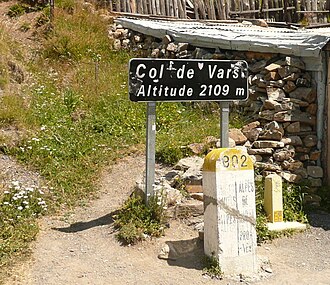
Col de Vars
| Col de Vars | |||
|---|---|---|---|
|
|
|||
| Compass direction | North | south | |
| Pass height | 2108 m | ||
| Department | Hautes-Alpes | Alpes-de-Haute-Provence | |
| Watershed | Torrent de Chagne → Guil → Durance | Mounal → Ubaye → Durance | |
| Valley locations | Guillestre | Jausiers , Saint-Paul-sur-Ubaye | |
| expansion | D902 | ||
| Built | 1809 | ||
| Winter closure | November to April | ||
| Mountains | French Alps | ||
| profile | |||
| Mountain scoring | 1 | 1 | |
| Ø pitch | 5.8% (1109 m / 19 km) | 8% (642 m / 8 km) | |
| Max. Incline | 9.8% | 10.6% | |
| map | |||
|
|
|||
| Coordinates | 44 ° 32 '20 " N , 6 ° 42' 10" E | ||
The Col de Vars is a pass in the French Alps . The pass is located on the border between the departments of Hautes-Alpes and Alpes-de-Haute-Provence in the region Provence-Alpes-Cote d'Azur . It connects the Ubaye valley with the Queyras valley and the city of Embrun via Mount Parpaillon . The pass is located at an altitude of 2108 m above sea level and is open from May to October. The pass has no classic winter closure. If the weather conditions are favorable, it is also open in winter.
The paved road D902 leads from Saint-Paul-sur-Ubaye ( 1466 m ) in the southeast over the pass to Vars ( 1860 m ) and on to Guillestre ( 1000 m ) in the northwest. The Col de Vars is part of the High Alpine Road Route des Grandes Alpes .
The Tour de France has moved to 2006 33 times over the Col de Vars.

