French Alps
| French Alps | |
|---|---|
|
Classic French division of the Alps |
|
| Highest peak | Mont Blanc ( 4810 m ) |
| location | France and Italy |
| part of | Alps |
| Coordinates | 44 ° 48 ′ N , 6 ° 30 ′ E |
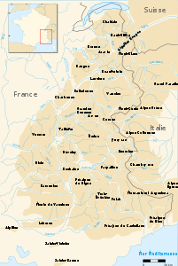
The French Alps are located in the southwestern part of the Western Alps and belong to France . The highest peak is the 4,810 m high Mont Blanc .
According to the Alpine Convention, they cover an area of 40,802 km² with 1,749 municipalities. They are located in the Auvergne-Rhône-Alpes and Provence-Alpes-Côte d'Azur regions .
The hilly areas in the south-west ( Massif des Maures ) are generally no longer included in the Alps.
structure
Classically, the Alps of France are divided - quite unspecifically - into:
- French high Alps , in the central area to the Swiss-Italian border
- Sea Alps , main Alpine ridge and pre-Alps against the Mediterranean
- French Alps , the western ridges and hills against the Rhone down
From a climatic-regional point of view, one roughly subdivides:
- Alpes du Nord , between Mont Blanc and Écrins , with the western pre-Alps
- Alpes du Sud , between Écrins and Grasse , with southwestern foreland
According to the SOIUSA division , France has a share in the following areas:
- (1) Ligurian Alps ( Punta Marguareis , 2,661 m)
- (2) Maritime Alps ( Monte Argentera , 3,297 m)
- (3) Provencal Pre-Alps ( Tête de l'Estrop , 2,961 m)
- (4) Cottian Alps ( Monviso , 3,841 m)
- (5) Dauphiné Alps ( Barre des Écrins , 4,102 m)
- (6) Dauphiné Pre-Alps ( Obiou , 2,790 m)
- (7) Graian Alps ( Mont Blanc , 4,810 m)
- (8) Savoy Prealps ( Haute Cime des Dents du Midi , 3,257 m)

NASA (2002), French Alps.
|
Individual evidence
- ↑ Key figures of the French convention area after the Alpine Convention
- ↑ something like: Météo-France: Montagne , with Alpes-Nord and Alpes-Sud
- ^ Sergio Marazzi: Atlante Orografico delle Alpi. SOIUSA . Pavone Canavese (TO), Priuli & Verlucca editori, 2005. ISBN 978-88-8068-273-8 (Italian); ders .: La “Suddivisione orografica internazionale unificata del Sistema Alpino” (SOIUSA) - article with detailed illustrations (pdf, ital .; 1.6 MB)

