Obiou
| Obiou | ||
|---|---|---|
|
The (big) Obiou |
||
| height | 2789 m | |
| location | department Isère | |
| Mountains | Dévoluy massif | |
| Coordinates | 44 ° 46 '30 " N , 5 ° 50' 23" E | |
|
|
||
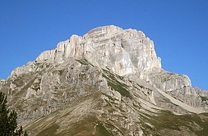
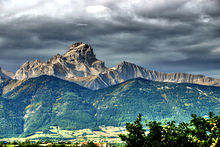
The Obiou ( French : Grande Tête de l'Obiou or more commonly l'Obiou ) is at 2789 meters the highest mountain in the Dévoluy massif , a mountain range of the French Limestone Alps off the Dauphiné Alps to the west . It is located in the Isère department .
geology
The mountain consists in its lower part of sediments of the Upper Jurassic and in its higher part of deposits from the Cretaceous period . Its characteristic shape was created by weathering and glacial erosion.
Tourist development
The Route Napoléon runs around 10 km northeast of Obiou, and the Route des Alpes 15 km west . Communities near the Obiou are Mens and Corps . The Obiou can be accessed from the Chalet des Baumes car park without climbing equipment. Other summit routes lead via via ferrata .
history
Two plane accidents have occurred at Obiou. In 1946, four people died when an American military plane hit one of the mountain slopes. On November 13, 1950, when a passenger plane crashed on the way from Rome to Paris, all of the occupants were killed: 51 Canadians returning from a pilgrimage to Rome and seven crew members.
Web links
Literature and map
- Iris Kürschner: Rother hiking guide, Dauphiné West - Vercors, Drôme provençale, Buëch, Dévoluy , Bergverlag Rother , Munich 2006, ISBN 978-3-7633-4334-8
- Institut Géographique National, hiking map 1: 25,000, sheet 3337 OT, Dévoluy, Obiou, Pic de Bure


