
Tete de l'Estrop
| Tete de l'Estrop | ||
|---|---|---|
 |
||
| height | 2961 m | |
| location | Alpes-de-Haute-Provence , Provence-Alpes-Cote d'Azur , France | |
| Mountains | Massif des Trois-Évêchés , Provencal Alps | |
| Coordinates | 44 ° 17 ′ 14 " N , 6 ° 30 ′ 17" E | |
|
||
| rock | Sandstone , limestone | |
| Age of the rock | Paleogene | |

The Tête de l'Estrop is a 2961 m high mountain in the Massif des Trois-Évêchés in the Provençal Alps in France .
location
The Tête de l'Estrop is located in the southwest of the Massif des Trois-Évêchés between Digne-les-Bains and Barcelonnette . It is the highest peak in the mountains. To the east is the winter sports resort of La Foux d'Allos , to the west is the 2820 m high Puy de la Sèche and the village of Le Vernet .
geology
The barren mountain consists primarily of Annot sandstone and is criss-crossed on the northwest side by maritime deposits, marl and limestone . On the north-western slope lies a large rock glacier , the Glacier de la Blanche . The tree line is around 2400 m. In the east, the ridge stretches over the Grosse Barre and the Petite Barre (2798 m) to the Trois Evêchés (2819 m).
gallery

In the background the Tête de l'Estrop, in front the waterfalls of the Piche
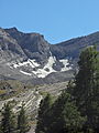
The Glacier de la Blanche

View from the north of the Tete de l'Estrop


Web links
- L'Estrop , geol-alp.com (French)