
Col de la Bonette
| Col de la Bonette | |||
|---|---|---|---|
 The pass crossing with the loop |
|||
| Compass direction | North | Southeast | |
| Pass height | 2715 m | ||
| department | Alpes-de-Haute-Provence , France | Alpes-Maritimes , France | |
| Watershed | Ubaye | Tinée | |
| Valley locations | Jausiers | Saint-Etienne | |
| expansion | Pass road | ||
| Built | 1960-1961 | ||
| Winter closure | October 1st - June 15th | ||
| Mountains | Maritime Alps | ||
| profile | |||
| Ø pitch | 6.8% (1502 m / 22 km) | 6.5% (1565 m / 24 km) | |
| Max. Incline | 9.0% (on km 14) | 15.0% (on km 12) | |
 |
|||
| map | |||
|
|||
| Coordinates | 44 ° 19 '36 " N , 6 ° 48' 26" E | ||

The Col de la Bonette is a 2715 m high mountain pass in the French Maritime Alps in the Provence-Alpes-Côte d'Azur region near the Italian border .
The pass marks the border between the departments of Alpes-de-Haute-Provence and Alpes-Maritimes . The narrow but continuously paved road ( SG 3 ) connects the valley of the Ubaye at Jausiers ( 1240 m ) with the valley of the Tinée at Saint-Étienne-de-Tinée ( 1144 m ). The road has been expanded to two lanes throughout the last few years, after some passages were single lane until the 1990s and two brooks had to be passed. The Cime de la Bonette (2860 m) and the Cime des Trois Serrières (2753 m) are the peaks that make up the pass.
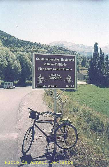
Highest public road in Europe for motorized vehicles
The approximately two kilometer long ring road around the Cime de la Bonette, which begins at the top of the pass, leads to 2802 m and is thus the second highest paved road in the Alps. Only the one at 2829 m above sea level is even higher . A. leading Ötztaler Gletscherstraße in Austria (although this is a dead end , unlike the one discussed here ).
The entrance to the pass is signposted, among other things, with “Plus haute route d'Europe” (German “Highest road in Europe”). However, the highest road in Europe is not in the Alps, but leads (as a dead-end street for motorized vehicles only with a permit) to the Pico del Veleta in the Sierra Nevada (Spain) .
Both climbs are equipped with special signs for cyclists at intervals of one kilometer .
The current course of the road was chosen over the top of the Col de la Bonette instead of the neighboring Col de la Moutière ( 2454 m ) a few hundred meters below . The pass road over the Col de Restefond and the Col de la Bonette is 49.1 km long, the shorter connection over the Col de la Moutière , which is still partly a natural road, is 45.7 km. This longer and higher course was probably chosen in order to achieve the prestigious title of “Highest Road in the Alps / Europe” and to be able to offer the traveler more impressive impressions. Another and more important reason that favored this choice in the period up to the Second World War was the military and strategic importance of the Bonette-Restefond-Ridge. The surveillance of this sector was essential for the control of the border area in the higher Tinée valley against the then hostile and fascist Italy.
course

The northern driveway to the pass begins in Jausiers. The road winds its way up through the narrowing valley. After around twenty kilometers you will reach the remains of the Casernes de Restefond at an altitude of around 2600 m . It is then another two kilometers to the intermediate Col de Restefond at 2680 m . It also forms the border with the Parc National du Mercantour , which the pass road crosses in the further course. From the Col de Restefond, the road continues to the Col de la Bonette, which is the actual culmination of this mountain route. The north ramp has the rank of a municipal road and bears the number C1.
At the top of the pass you have the option of either going through a short rock breakthrough directly to the south-east ramp of the pass or of going around the 2862 m high Cime de la Bonette via a ring-shaped road . In the course of this approximately two-kilometer-long ring road, one reaches at 2802 m one of the highest points that can be approached on a paved road in the Alps. From here the Cime de la Bonette can be reached in about ten minutes on foot, from there you have a panoramic view of the Mercantour National Park with its impressive scree desert.
From the top of the pass, the southeast ramp leads after a good two kilometers over the Col de Raspaillon ( 2513 m ) and after a further two kilometers through the small military camp Camp des Fourches at an altitude of 2271 m . The lower part of the road runs through the Tinée Valley before reaching Saint-Étienne.
Strictly speaking, the pass road does not lead over the pass height of the Col de Restefond, which is actually a little more northerly, but touches it at a distance of only about 20 meters. The small road over the top of the pass, about 2 kilometers long and closed to cars, branches off the main road shortly before and runs north of the Cime des Trois Serrières ( 2753 m ) and Tête de Brague ( 2693 m ). At the Col de Raspaillon this meets the main road again.
As an alternative to the road over the top of the Col de la Bonette, the Col de la Moutière runs southwest past the Cime de la Bonette. The northern junction at Col de Restefond leads as a dirt road after a few kilometers to the top of the pass at 2,454 m and from there asphalted to the confluence at Saint-Dalmas-le-Selvage, which is much further southeast.
history
From 1890 on, several military structures were erected in the area of Restefond and Bonette, two of which are directly on today's road. The north ramp leads around the fortified Casernes de Restefond , the ruins are still relatively well preserved. On the south-east ramp, the road leads through the Camp des Fourches at 2271 m , a former military camp whose houses are now only ruins.
In 1913 the piste du haut up to Camp des Fourches was completed on the southeast side .
1931–1940 bunker systems of the Maginot Line were built. B. above the road between the pass heights of Restefond and Bonette.
Today's road was built between 1960 and 1961, as can be seen from the memorial stone at the highest point.
In terms of traffic technology, the connection is of little importance to this day.
Tour de France
The pass has been crossed four times in the history of the Tour de France . In 1962 and 2008 the stages were led from the south over the summit of; In 1964 and 1993 the field of drivers approached from the north. The leaders at the top of the pass were Federico Bahamontes in 1962 and 1964, Robert Millar in 1993 and John-Lee Augustyn in 2008, before he fell on the descent to Jausiers.
On July 11, 1962, this was the 18th stage from Antibes to Briançon over 241.5 km, which Emile Daems won. On June 30, 1964, the 9th stage led from Briançon to Monaco and was won by Jacques Anquetil after 239 km . The 11th stage on July 15, 1993 led from Serre Chevalier over 179 km to Isola 2000 . Tony Rominger won this. On July 22, 2008, the 16th stage began in Cuneo and ended in Jausier, making the Col de la Bonette shortly before the end of the stage for the first time. After 157 km, Cyril Dessel won .
Illustrations

The top of the pass seen from the Cime de la Bonette. In the foreground the two ends of the Ringstrasse.

Casernes de Restefond

Camp des Fourches

The driveway to the Ringstrasse, still closed at the end of May

View towards the southeast (Tinée valley)

Driveway to the northwest on the Tinée side

One of the special kilometer marks for cyclists on the ascent of Jausiers

South side

North side


Web links
- Slope profile of the north ramp or south ramp , each up to the top of the Col de la Bonette
Individual evidence
- ↑ "Plus haute route d'Europe"
- ^ Boundary stone at the Camp des Fourches
- ↑ Information board at the Camp des Fourches
- ↑ Information boards at the Casernes de Restefond
Agnel • Allos • Andrion • Aravis • Bonette • Braus • Cayolle • Champs • Colle-Saint-Michel • Colombière • Croix de Fer • Croix-Fry • Cuillole • Galibier • Gets • Glandon • Granon • Iseran • Izoard • Jambaz • Joux Plane • Joux Verte • Larche • Lautaret • Lebraut • Lombarde • Madeleine • Saint Martin • Méraillet • Mollard • Mont Cenis • Montets • Montgenèvre • Morgins • Moutière • Ornon • Pré • Petit Saint-Bernard • Pontis • Ramaz • Roselend • Rousset • Saisies • Télégraphe • Tende • Turini • Valberg • Vars