
Saint-Etienne-de-Tinée
| Saint-Etienne-de-Tinée | ||
|---|---|---|
.svg)
|
|
|
| region | Provence-Alpes-Cote d'Azur | |
| Department | Alpes-Maritimes | |
| Arrondissement | Nice | |
| Canton | Tourrette-Levens | |
| Community association | Nice Cote d'Azur | |
| Coordinates | 44 ° 15 ′ N , 6 ° 56 ′ E | |
| height | 949-3,027 m | |
| surface | 173.82 km 2 | |
| Residents | 1,531 (January 1, 2017) | |
| Population density | 9 inhabitants / km 2 | |
| Post Code | 06660 | |
| INSEE code | 06120 | |
 View from the east |
||

Saint-Etienne-de-Tinée is a French commune in the Alpes-Maritimes in the region Provence-Alpes-Cote d'Azur . It belongs to the Arrondissement of Nice , the canton of Tourrette-Levens and is a member of the Métropole Nice Côte d'Azur municipal association . The residents call themselves Stéphanois .
geography
Saint-Étienne-de-Tinée is the northernmost municipality in the Alpes-Maritimes department. It is located in the French Maritime Alps . It borders in the northeast on Argentera in Italy , in the southeast on Isola , in the south on Beuil , Péone and Guillaumes (point of contact), in the southwest on Châteauneuf-d'Entraunes , in the west on Entraunes and Saint-Dalmas-le-Selvage and in the northwest to Jausiers and Val d'Oronaye . The Tinée river has its source in the municipality .
Population development
| year | 1962 | 1968 | 1975 | 1982 | 1990 | 1999 | 2008 | 2014 |
|---|---|---|---|---|---|---|---|---|
| Residents | 1,505 | 1,549 | 1,700 | 1,780 | 1,783 | 1,528 | 1,324 | 1,385 |
Attractions
See: List of Monuments historiques in Saint-Étienne-de-Tinée

Saint-Maur Chapel, Monument historique

Saint-Erige Chapel in Auron , Monument historique
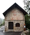
Saint-Sébastien Chapel, Monument historique

Tower of the Saint-Etienne church, monument historique

Sébastien Fabri's house, Monument historique
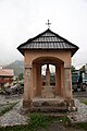
Oratory , Monument historique


literature
- Le Patrimoine des Communes des Alpes-Maritimes . Flohic Editions, Volume 2, Paris 2000, ISBN 2-84234-071-X , pp. 829-835.
Web links
- Saint-Étienne-de-Tinée website (French)