
La Roquette-sur-Var
| La Roquette-sur-Var | ||
|---|---|---|

|
|
|
| region | Provence-Alpes-Cote d'Azur | |
| Department | Alpes-Maritimes | |
| Arrondissement | Nice | |
| Canton | Tourrette-Levens | |
| Community association | Nice Cote d'Azur | |
| Coordinates | 43 ° 50 ′ N , 7 ° 12 ′ E | |
| height | 108-600 m | |
| surface | 3.99 km 2 | |
| Residents | 940 (January 1, 2017) | |
| Population density | 236 inhabitants / km 2 | |
| Post Code | 06670 | |
| INSEE code | 06109 | |
 La Roquette-sur-Var |
||

La Roquette-sur-Var is a French commune in the Alpes-Maritimes in the region Provence-Alpes-Cote d'Azur . It belongs to the Arrondissement of Nice , the Canton of Tourrette-Levens and the Métropole Nice Côte d'Azur . The residents are the Roquettans.
geography
The neighboring parishes are Levens , Saint-Blaise , Saint-Martin-du-Var , Gilette and Bonson . The village at an altitude of 380 m. The river Var forms the municipality boundary in the northeast. The national route 202 and the meter-gauge railway line Nice – Digne-les-Bains of the Chemins de fer de Provence run parallel to this .
Population development
| year | 1962 | 1968 | 1975 | 1982 | 1990 | 1999 | 2007 | 2016 |
|---|---|---|---|---|---|---|---|---|
| Residents | 538 | 537 | 506 | 565 | 660 | 820 | 928 | 923 |
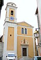
Saint-Pierre church

The Var with a weir


Attractions
See: List of Monuments historiques in La Roquette-sur-Var
literature
- Le Patrimoine des Communes des Alpes-Maritimes . Flohic Editions, Volume 1, Paris 2000, ISBN 2-84234-071-X , pp. 465-468.
Web links
Commons : La Roquette-sur-Var - Collection of images, videos and audio files