
L'Escarène
| L'Escarène | ||
|---|---|---|

|
|
|
| region | Provence-Alpes-Cote d'Azur | |
| Department | Alpes-Maritimes | |
| Arrondissement | Nice | |
| Canton | Contes | |
| Community association | Pays des Paillons | |
| Coordinates | 43 ° 50 ′ N , 7 ° 21 ′ E | |
| height | 220-1,054 m | |
| surface | 10.67 km 2 | |
| Residents | 2,520 (January 1, 2017) | |
| Population density | 236 inhabitants / km 2 | |
| Post Code | 06440 | |
| INSEE code | 06057 | |
 L'Escarène |
||

L'Escarène is a French commune in the Alpes-Maritimes in the region Provence-Alpes-Cote d'Azur . It belongs to the canton of Contes in the Arrondissement of Nice . The inhabitants call themselves the Escarénois.
geography
L'Escarène is located in the French Maritime Alps . The neighboring communities are:
- Lucéram and Touët-de-l'Escarène in the north,
- Peille in the east,
- Blausasc in the south,
- Berre-les-Alpes to the west.
The Paillon flows through L'Escarène . The village is served by the standard-gauge railway line Nice - Breil-sur-Roya (branch line of the Tendabahn ).
Population development
| year | 1962 | 1968 | 1975 | 1982 | 1990 | 1999 | 2008 | 2012 |
|---|---|---|---|---|---|---|---|---|
| Residents | 1,223 | 1,619 | 1,553 | 1,424 | 1,751 | 2.128 | 2,342 | 2,449 |
Attractions
See: List of Monuments Historiques in L'Escarène
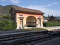
L'Escarène train station

Pont-Vieux

Saint-Pierre-ès-Liens church


literature
- Le Patrimoine des Communes des Alpes-Maritimes . Flohic Editions, Volume 1, Paris 2000, ISBN 2-84234-071-X , pp. 342-346.
Web links
Commons : L'Escarène - collection of images, videos and audio files