
Tendabahn
| Tendabahn | |||||||||||||||||||||||||||||||||||||||||||||||||||||||||||||||||||||||||||||||||||||||||||||||||||||||||||||||||||||||||
|---|---|---|---|---|---|---|---|---|---|---|---|---|---|---|---|---|---|---|---|---|---|---|---|---|---|---|---|---|---|---|---|---|---|---|---|---|---|---|---|---|---|---|---|---|---|---|---|---|---|---|---|---|---|---|---|---|---|---|---|---|---|---|---|---|---|---|---|---|---|---|---|---|---|---|---|---|---|---|---|---|---|---|---|---|---|---|---|---|---|---|---|---|---|---|---|---|---|---|---|---|---|---|---|---|---|---|---|---|---|---|---|---|---|---|---|---|---|---|---|---|---|
 | |||||||||||||||||||||||||||||||||||||||||||||||||||||||||||||||||||||||||||||||||||||||||||||||||||||||||||||||||||||||||
| Route number (SNCF) : |
Nice-Breil-sur-Roya: 945,000 Coni-Ventimiglia: 946,000 |
||||||||||||||||||||||||||||||||||||||||||||||||||||||||||||||||||||||||||||||||||||||||||||||||||||||||||||||||||||||||
| Route number (RFI) : | 7th | ||||||||||||||||||||||||||||||||||||||||||||||||||||||||||||||||||||||||||||||||||||||||||||||||||||||||||||||||||||||||
| Course book route (SNCF) : | 506 | ||||||||||||||||||||||||||||||||||||||||||||||||||||||||||||||||||||||||||||||||||||||||||||||||||||||||||||||||||||||||
| Course book series (IT) : | 109 | ||||||||||||||||||||||||||||||||||||||||||||||||||||||||||||||||||||||||||||||||||||||||||||||||||||||||||||||||||||||||
| Route length: |
Cuneo – Ventimiglia: 99.4 km Cuneo – Nice: 121.2 km |
||||||||||||||||||||||||||||||||||||||||||||||||||||||||||||||||||||||||||||||||||||||||||||||||||||||||||||||||||||||||
| Gauge : | 1435 mm ( standard gauge ) | ||||||||||||||||||||||||||||||||||||||||||||||||||||||||||||||||||||||||||||||||||||||||||||||||||||||||||||||||||||||||
| Cuneo – Ventimiglia | |||||||||||||||||||||||||||||||||||||||||||||||||||||||||||||||||||||||||||||||||||||||||||||||||||||||||||||||||||||||||
|
|||||||||||||||||||||||||||||||||||||||||||||||||||||||||||||||||||||||||||||||||||||||||||||||||||||||||||||||||||||||||
| Branch line to Nice | |||||||||||||||||||||||||||||||||||||||||||||||||||||||||||||||||||||||||||||||||||||||||||||||||||||||||||||||||||||||||
|
|||||||||||||||||||||||||||||||||||||||||||||||||||||||||||||||||||||||||||||||||||||||||||||||||||||||||||||||||||||||||

The Tendabahn is an extraordinary standard-gauge railway line through the Alps . It connects the Italian city of Turin via Cuneo with the French Nice and crosses under the main ridge of the Maritime Alps below the Colle di Tenda in a tunnel over eight kilometers long . South of the tunnel it is part of the extended area around the French Mercantour National Park .
Due to the location near the border between France and Italy and various compromises between two European countries, the construction of the line dragged on for over 50 years. This is why there is a train station in Breil-sur-Roya in the middle of the alpine mountains with two branches: one branch leads from there as a main route to Italy , the other branch as a branch to France . It is also unusual that there are fortifications in various tunnels .
From the apex of the Tenda tunnel to the level of the Mediterranean Sea, the route has to overcome a difference in altitude of more than 1000 meters; this order of magnitude is only exceeded within Europe by the mountain routes of the Rhaetian Railway . The continuous single-track route is almost 100 kilometers long. The maximum gradient of the route is 25 ‰ with a minimum curve radius of 300 meters. These route parameters enable a top speed of 80 kilometers per hour . Between Bevera and Robilante , 58 percent of the main route is run in tunnels.
The route of the Tendabahn runs in parts in an area that is geologically very active. This primarily concerns the section between Breil-sur-Roya and Nice. This activity manifests itself in a creeping landslide that repeatedly deforms the track . For this reason, you may not drive faster than 10 km / h in these sections. The trunk line is also endangered by falling rocks, which is why it is secured at such points with a cage made of indicator wires. If damaged by falling stones, the wires immediately interrupt traffic by stopping all signals . A special feature are the signals between Breil-sur-Roya and Tende , although they are in French territory, of Italian design.
This shows that the fate of the international tenda railway has been in Italian hands since 1970: At that time Italy and France had contractually stipulated that Piedmont alone would bear the maintenance costs of the entire railway line. The planned closure in 2013 sparked Italian-French protests at the end of April. The supporters of the railway demanded a revision of the convention of 1970 and a rescue of the line by a cost sharing between both countries. Several pairs of trains were guaranteed up to 2016; if the Tende tunnel is temporarily closed, train and bus operations will continue.
Route history
First plans

Around 1851 various railway projects for the connection Piedmont - Mediterranean were created . The Turin - Savona line was opened in 1874. In 1856 a project was proposed by engineer Filippo Cerotti and came very close to the Tenda line that was finally realized. One difference was the alignment in the lower Roya valley through the Ventimiglias bypass to the coast and along this to Nice .
In 1857 the engineer Petit-Nispel presented a counter-project commissioned by the city of Nice: The proposed route led north through the Paillon valley, then through the Vesubie gorge , under the Col de Pagari and down the Gesso valley to Cuneo . The project was rejected as early as 1858. The Kingdom of Sardinia ceded Savoy, including Nice and the hinterland, to France in 1860 . The lower Roya valley remained near Sardinia-Piedmont, the middle section of the valley became French, the two highest municipalities, La Brigue and Tenda, remained Sardinian. This was justified with the retention of the hunting grounds of King Viktor Emanuel II. In addition, strategic reasons were also mentioned .
The "Plan Freycinet", a French program for the expansion of the railway in 1859 saw a connection Nice- Sospel - Breil-sur-Roya before connecting to the border above Fontan. In Italy, the law necessary to build the Tenda line was adopted at the same time. For strategic reasons, the railway project arose from 1875 in France resistance. The issue of military security weighed on the project for the next 30 years. For this reason purely Italian routes were also proposed.
Construction of the Tendabahn


In 1883 construction began near Cuneo. Concerns about national security led to the closure of the French design office for the line in 1887. In 1889 construction began on the 8099 meter long Tenda tunnel , and in 1898 the breakthrough was celebrated.
In 1900 the French Minister of War and the Minister of Public Works agreed on the Nice – Breil-sur-Roya link and on to the national border. In Italy, there were again suggestions for the purely Italian continuation of the Tendabahn, but then the construction of a second long vertex tunnel would have been necessary. In 1903 it was proposed in Nice to build the tunnel planned between Sospel and Breil-Sur-Roya under the (at that time) Italian Monte Graziano in order to shorten it by 1000 meters. This variant required a special agreement between the two states, but was eventually built. With a total length of 3882 meters, 2305 meters were on Italian territory (at that time), while the two tunnel portals were in France. In 1904 an Italian-French agreement was signed, according to which the entire line should be completed by 1914.
In 1908 construction began between Ventimiglia and the border in the lower Roya valley towards Breil-Sur-Roya, and in 1912 construction began on the Col de Braus tunnel (length 5938 meters) between Breil-Sur-Roya and Nice. In 1914 construction was stopped because of the outbreak of the First World War in France. Construction continued in Italy. In 1915 Italy entered the war by declaring war on Austria-Hungary .
After the end of the war, construction began in 1921 on the connection's two major bridges, the Viaduc de Scarassoui and the Viaduc de Saorge, which were completed in 1923.
Inauguration and start of operations
In 1928 the end-to-end connection between Ventimiglia and Cuneo and the side line between Nice and Breil-sur-Roya were inaugurated. From 1931 the Italian sections from Ventimiglia to Piena (today: Piène) and from Cuneo to St-Dalmas de Tende were electrified with three-phase alternating current . Electrification of the French section will not take place for the time being.
In 1934 the French military approved the electrification of the section from Piena via Breil-Sur-Roya to St-Dalmas. The work was completed in 1935. By eliminating the need to change locomotives twice, travel times between Ventimiglia and Cuneo have been reduced by 30 minutes. The economic crisis, protectionism and the deterioration of political agreement between Italy and France led to a sharp decrease in traffic on all lines between the two countries from 1937 onwards. With the beginning of the Second World War , cross-border traffic was almost completely stopped from 1939.
Destruction in World War II
In 1940 Italy declared war on France. The systems of the Mont Grazian tunnel, other French railway systems and the Viaduc de Saorge were destroyed. After the armistice , the reconstruction began by the Italians. The work was completed that same year. Operation on the Ventimiglia – Cuneo line was resumed on November 17, 1940, the only user initially being the military.
The armistice between Italy and the Allies was signed in 1943. The Viaduc de Saorge was destroyed for the second time by the Italians and then temporarily rebuilt by the Germans. The German withdrawal from the Roya valley took place in 1945. In addition to many other structures, the Viaduc de Saorge was destroyed for the third time. In the summer of 1945, rail operations between Nice and Sospel were resumed and the telegraph line was restored on the entire route. During the last years of the war, a train with a passenger car and a locomotive was trapped in the top tunnel because the next bridges were destroyed.
Post War and Reconstruction

The section from Cuneo to Viévola, which was only slightly damaged, was put back into operation in 1946. The Paris Peace Treaty ended the war between Italy and France in 1947. Border corrections were agreed so that the common border came to rest in the Tenda tunnel. In addition, the border was moved so that the Mont Grazian tunnel was now entirely in France. The Sospel – Breil-Sur-Roya section was put back into operation, but passenger traffic between Limone and Viévola through the Tenda tunnel was discontinued after the border shift. The route between Limone and Viévola was still reserved for sporadic timber transport by the Italian state railways. In 1963, France agreed to rebuild the Ventimiglia – Viévola connection at the request of Italy. This decision was made easier in France by the fact that Italy agreed to bear a large part of the construction costs for the sections located in France. In 1973 work began in the Italian Roya Valley (Ventimiglia – Piène), as well as in 1976 on the French section of the route. Almost all large bridges had to be rebuilt. The Tendabahn was reopened on October 6, 1979. The electrification south of Limone, which existed from 1935 to 1940, was not restored.
On January 27, 2003, two trains collided in the tunnel de Biogna, causing two fatalities and four seriously injured. A plaque at the train station of St. Dalmas de Tende commemorates the event. Between September 4, 2017 and July 13, 2018, the line between Cuneo and Ventimiglia was rehabilitated; trains only ran on the line from Breil-sur-Roya to Nice.
Exceptional bridges and tunnels
As can be seen from the route history given above, the Tendabahn is rich in bridges and tunnels .
Important tunnels on the trunk line


There are 83 tunnels on the Cuneo - Ventimiglia trunk line and 24 tunnels on the Breil-sur-Roya - Nice branch . On the south ramp of the route between Breil-Sur-Roya and the Tenda tunnel, there are a total of seven tunnels, which are used exclusively to gain height. Four of these tunnels are spiral tunnels and three more are spiral tunnels. On the other hand, there is only one roundabout tunnel on the north ramp. The following list only includes tunnels longer than 500 meters:
| Surname | Length in meters |
comment |
|---|---|---|
| Tenda vertex tunnel | 8099 | 3732 m are in France, 4367 m in Italy |
| Tunnel de Bergue | 1884 | Spiral tunnel |
| Tunnel de Rioro | 1828 | Roundabout tunnel |
| Tunnel de Paganin | 1702 | |
| Tunnel de Bosseglia | 1583 | Spiral tunnel |
| Galleria Elicoidal di Vernante | 1502 | Roundabout tunnel |
| Cagnolina tunnel | 1468 | Roundabout tunnel |
| Galleria dell 'Altipiano | 1276 | |
| Branego tunnel | 1273 | Spiral tunnel |
| Porcarezzo tunnel | 1250 | Spiral tunnel |
| Tunnel du Gigne | 1186 | |
| Tunnel de Biogna | 1154 | Spiral tunnel |
| Galleria Boglia | 1086 | |
| Galleria Bocce | 931 | |
| Galleria Lamberta | 850 | |
| Tunnel de l'Agrie | 835 | |
| Galleria Sardinesca | 820 | |
| Galleria Para | 754 | |
| Tunnel de la Frontiere | 743 | |
| Devenzo tunnel | 733 | |
| Fromentino tunnel | 646 | |
| Tunnel de Precipus | 622 | |
| Galleria Mantici | 604 | |
| Galleria Colombo | 601 |

The trunk line runs a total of 34.6 kilometers below the surface and is 62.4 kilometers long.
Significant tunnels on the branch line
| Surname | Length in meters |
|---|---|
| Tunnel du Col Braus | 5938 |
| Tunnel du Mont Grazian | 3882 |
| Tunnel de Caranca | 915 |
| Santa Augusta tunnel | 754 |
| Tunnel de Carabacel | 663 |
| Tunnel de l'Escarene | 527 |
At the exit from the station of Breil-sur-Roya towards Nice crosses Tunnel de Caranca twice the Tunnel de Gigne .
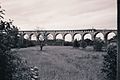
Important bridges on the trunk line

Due to the lines along the steep and narrow Roya Valley, the route often has to cross this valley on bridges . Some of the bridges are almost 60 meters high. After the destruction of the Second World War , almost all bridges had to be rebuilt. For most of these bridges reinforced concrete was used, which allows a completely different architecture of the bridge structure. The reconstruction was completed in 1979.
| Surname | Height in meters |
Length in meters |
|---|---|---|
| Viaduc de l'Erbossiera | 48 | 205 |
| Viaduc des Eboulis | 22nd | 270 |
| Viaduc de la Maglia | 18th | 162 |
| Viaduc de Scarassoui | 38 | 125 |
| Viaduc de Saorge | 60 | 58 |
| Viaduc de l'Usine Electrique | 31 | 107 |
| Viaduc de Tende | 36 | 191 |
| Viaduc de St. Dalmas | 24 | 130 |
| Viaduc de la Chapelle | 32 | 89 |
| Viadotto Rivoira | 45 | 233 |
Important bridges on the branch line
| Surname | Height in meters |
Length in meters |
|---|---|---|
| Viaduc de la Launa | 30th | 135 |
| Viaduc de Faquin | 25th | 125 |
| Viaduc de l'Erbossiera | 48 | 205 |
| Viaduc de l'Euira | 27 | 70 |
| Viaduc de l'Escarene | 38 | 225 |
| Viaduc de Bassera | 26th | 140 |
| Viaduc de Bancao | 21st | 125 |
| Viaduc de Bevera | 30th | 125 |
The construction of the Viaduc de Bevera, also known as Viaduc du Caï , is unusual in the high mountains. The bridge girder of the viaduct, which was completed in 1898, is made of steel and is supported in the middle by an arch that is at right angles to the actual bridge. This peculiar design results from the fact that the bridge crosses a ravine at an acute angle; an arch in the classic design would have been disproportionately large. Military requirements are also held responsible for the unusual bow position. The content of this was that the bow should be destroyed by fire with artillery from a nearby French fort in the event of an Italian invasion on the route. This bridge, too, fell victim to the war in 1940 and was not rebuilt until 1962, with a concrete arch replacing its stone predecessor.
Also worth mentioning is the Viaduc des Morts (German: Totenviadukt) near Peillon-Ste-Thècle . The bridge is located above an old road that was used by the residents of the village of Borghéas (Peillon commune) to transport their dead to the Drap cemetery.
A second bridge runs parallel to this bridge at a distance of a few meters, but it never went into operation. It already became meaningless during the construction of the line due to an irreparable tunnel collapse. Three construction workers were killed in this accident.
The name of the later viaduct did not come about because of the accident during the construction of the tunnel, but because of the aforementioned cemetery path. Because already on the construction drawings of the first bridge from 1912 it can be seen that the bridge was named Totenviadukt even then.
Fortifications in the tunnels

Due to the political tensions between France and Italy in the 19th century, the route was equipped with fortifications . On portals of some tunnels today are loopholes to be recognized. Various tunnels were excavated for a two-lane cross-section, but the line was only expanded to a single track. There are still ruins of large forts and barracks on the Tenda Pass .
In the vicinity of L'Escarene there are extensive installations of the Maginot Line , the entrance to the Col du Braus tunnel near Sospel is secured by an armored gun emplacement from this period.
Accidents
On January 27, 2003, two passenger trains collided head-on in a tunnel near the French-Italian border. Two people died (engine driver and conductor of the train coming from Italy) and five people were seriously injured.
Operation on the route
passenger traffic

In 2005 there was a lot of local traffic on the Cuneo – Breil-sur-Roya – Ventimiglia branch. The trains ran roughly every two hours, with additional trains at certain times of the day. Two pairs of trains ran continuously between Nice and Cuneo, one of these pairs of trains also went beyond Cuneo to / from Turin . A pair of trains marketed in the Nice area as an excursion train under the name “Train des Merveilles” (German: “Train of Miracles”) also ran between Nice and Tende. The name refers to the Vallée des Merveilles , which is most easily reached via Saint Dalmas de Tende and which is not only a popular destination, but is also of outstanding archaeological importance.
On the French part of Nice – Breil-sur-Roya, the transport offer was rather thin compared to the Cuneo – Ventimiglia connection with six pairs of trains, but average for French branch lines. Additional suburban trains were offered between Nice and Drap-Cantaron. The travel time from Cuneo to Nice was about three hours and from Cuneo to Ventimiglia about two hours.
The tariffs are very different due to the cross-border traffic. For connections from Italy to Italy via French territory, only the (cheaper) Italian tariff is used, within France the (more expensive) French tariff and the international tariff for cross-border traffic. Curiously, this z. B. a ticket from Limone to Ventimiglia cheaper than from Tende to Breil-sur-Roya.
Freight transport
The Tendabahn is currently only used for passenger traffic on the French side. Freight transport is currently only offered on the Italian side as far as Limone, the primary transport goods are cement .
Used locomotives


From the opening of the line in 1928 to the electrification of the main line in 1935 with the Italian three-phase AC system , steam locomotives were used , then three-phase FS locomotives . The French branch line between Breil-sur-Roya and Nice, however, was never electrified.
During the Second World War, the catenary systems on the line were dismantled and used for other purposes, and steam locomotives were once again sufficient for the low military traffic requirements. The remnants of the overhead lines were removed during the reopening work, but they can still be recognized, for example, from the locomotive shed in Breil-sur-Roya station or the bridges en route.
From 1979 diesel multiple units predominated on both routes , with the French State Railways using vehicles from the X 4500 series and the Italian State Railways using the ALn 668 and ALn 663 series . The X 4500 series railcars were replaced by the X 2200 series from 1995 , which, with their more powerful engines, were better suited for the route. They are still on the road today as the Train des Merveilles . The vehicles have a special paint job in accordance with their task as an excursion train. It shows motifs from excursion destinations along the route.
Since 2005, the Italian and French state railways have been using modern three-part diesel multiple units for passenger transport on both branches of the route, which also have space reserves for larger tour groups. The French vehicles with the series designation AGC ( Autorail à Grande Capacité ) and the Italian vehicles with the designation Minuetto have large panoramic windows through which the passing landscape can be observed. These railcars also provide the daily long-distance connection between Turin and Imperia via the Tenda line.
The relatively low freight traffic on the Italian side from Cuneo to Limone is handled by electric locomotives with the direct current drive common in Italy today . Three-phase locomotives were still in operation there until the 1970s. Freight traffic on the French side ceased in 1988.
Train stations

With the completion of the Cuneo (Altipiano) station, the starting point of the Tendabahn was moved there; the old line via Boves was served by local trains until 1960. With the transition to France, the towns of Tenda, La Briga and San Dalmazzo di Tende were given their current names, and the station names were adapted when the system was restarted. The Piena station was renamed, but no longer operated. In this area, the Royatal valley is so narrow that the station had to be placed on a specially built bridge in order to leave room for the road. There is a small railway and bus museum in the Breil-sur-Roya train station area. Furthermore, the station of St. Dalmas de Tende presents itself as a monumental building of the Mussolini era . The station served as a border station to France until 1940 and was carried out in a representative manner. Clara Petacci lived there and was often visited by Mussolini.
On the branch route Nice – Breil-Sur-Roya, the kilometers are set from Nice. The route of the Train des Merveilles is entirely in France.
Picture gallery

Vievola station with diesel multiple units of the series ALn 663 of the FS , 2009

Abandoned Airole station with type ALn 501/502 railcars of the FS

Italian railcar leaving the current Airole station

Viaduct in the upper Royatal with remains of catenary masts
Double-decker bridge for road and rail in Cuneo


Movie
- Alexander Schweitzer: By train through ... Provence . ARTE GEIE / SWR, Germany, 2008, 43 min.
- Mathias Werth: Tal des Zorns - Resistance in France's Alpine world , documentary film report on the citizens' resistance to the neglect of the Tendebahn line in need of repair. 29:06 min.
literature
- Rudolf W. Butz: The Tenda line, reconstruction of an alpine railway. Orell Füssli, Zurich 1984, ISBN 3-280-01553-7 .
Web links
- A German-language website about the Tendabahn with travel tips
- Tendabahn. In: Structurae
- Comprehensive site with maps and many historical pictures (French)
- Map section with the French and part of the Italian route
Individual evidence
- ↑ Protests against the closure of the Tendabahn - Quotidiano online della Provinzia di Cueno
- ↑ Slightly reduced but guaranteed train service in 2013
- ↑ Train and bus operation due to Closure of the Tende tunnel April – May 2016 ( memento of the original from June 3, 2016 in the Internet Archive ) Info: The archive link was inserted automatically and has not yet been checked. Please check the original and archive link according to the instructions and then remove this notice.
- ↑ Report a frontal collision on the Tendabahn . In: Eisenbahn-Revue International , Issue 3/2003, ISSN 1421-2811 , p. 128.
- ↑ Tendabahn reopened in Lok Magazin 10/2018, p. 39.
- ↑ Tunnel de Rioro. (PDF) In: Inventaire des tunnels ferroviaires de France. Retrieved June 6, 2016 (French).
- ↑ Tunnel de Paganin. (PDF) In: Inventaire des tunnels ferroviaires de France. Retrieved June 6, 2016 (French).
- ↑ Swiss Railway Review 3/2003 page 128
- ↑ Trenitalia online ticket. Retrieved May 28, 2013 .
- ↑ SNCF online ticket. Retrieved May 28, 2013 .
- ^ Film contribution (“By train through ... the Provence”, 2008) by ARTE
- ↑ By train through ... Provence ( Memento of the original from November 12, 2012 in the Internet Archive ) Info: The archive link was automatically inserted and not yet checked. Please check the original and archive link according to the instructions and then remove this notice. . (About 20 minutes to the Train des Merveilles)
- ↑ Report in the First: Valley of Anger ( Memento from October 23, 2015 in the Internet Archive ), broadcast on ARD October 24, 2015
Coordinates: 43 ° 56 ′ 38 " N , 7 ° 30 ′ 55" E