
Daluis
| Daluis | ||
|---|---|---|

|
|
|
| region | Provence-Alpes-Cote d'Azur | |
| Department | Alpes-Maritimes | |
| Arrondissement | Nice | |
| Canton | Vence | |
| Community association | Alpes d'Azur | |
| Coordinates | 44 ° 1 ′ N , 6 ° 49 ′ E | |
| height | 590-2,502 m | |
| surface | 40.03 km 2 | |
| Residents | 146 (January 1, 2017) | |
| Population density | 4 inhabitants / km 2 | |
| Post Code | 06470 | |
| INSEE code | 06053 | |
 View of Daluis |
||

Daluis is a French commune in the Alpes-Maritimes in the region Provence-Alpes-Cote d'Azur . It belongs to the Arrondissement of Nice and the Canton of Vence . The residents call themselves Daluisiens .
geography
The municipality is located in the French Maritime Alps and borders Sauze and Guillaumes to the north, La Croix-sur-Roudoule to the east, Saint-Léger to the south, Sausses to the southwest and Castellet-lès-Sausses to the west . The Var flows through Daluis, and on the route from Guillaumes to Darluis, the Gorges de Daluis formed a deeply cut canyon .
Population development
| year | 1962 | 1968 | 1975 | 1982 | 1990 | 1999 | 2008 | 2012 |
|---|---|---|---|---|---|---|---|---|
| Residents | 182 | 202 | 185 | 124 | 110 | 132 | 126 | 152 |

Mont Saint Honorat

Pont de la Mariée
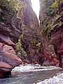
Var in the Gorges de Daluis gorge .


religion
The Church of St. Coelestin (Saint-Célestin) belongs to the parish of St. John the Baptist (Saint-Jean-Baptiste) with its seat in Guillaumes , Diocese of Nice .
literature
- Le Patrimoine des Communes des Alpes-Maritimes . Flohic Editions, Volume 1, Paris 2000, ISBN 2-84234-071-X , pp. 413-414.
Web links
Individual evidence
- ↑ Scooter tour France - Alpes de Haute Provence. Geo.de, 2010, accessed on August 17, 2015 .
- ↑ Gorges de Daluis gorge (Alpes-Maritimes). Retrieved August 17, 2015 .