Var (river)
| Var | ||
|
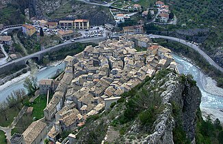
The river in Entrevaux |
||
| Data | ||
| Water code | FR : Y6-0200 | |
| location | France , Provence-Alpes-Cote d'Azur region | |
| River system | Var | |
| source | in the municipality of Entraunes , near the Col de la Cayolle 44 ° 14 ′ 18 ″ N , 6 ° 45 ′ 6 ″ E |
|
| Source height | approx. 1790 m | |
| muzzle | on the municipal boundary of Nice and Saint-Laurent-du-Var in the Mediterranean Sea Coordinates: 43 ° 39 ′ 15 ″ N , 7 ° 12 ′ 0 ″ E, 43 ° 39 ′ 15 ″ N , 7 ° 12 ′ 0 ″ E |
|
| Mouth height | 0 m | |
| Height difference | approx. 1790 m | |
| Bottom slope | approx. 16 ‰ | |
| length | 114 km | |
| Catchment area | 2820 km² (at Pont Napoléon III in Nice) | |
| Left tributaries | see table tributaries | |
| Right tributaries | see table tributaries | |
| Big cities | Nice | |
| Medium-sized cities | Saint-Laurent-du-Var | |
| Small towns | Carros , La Gaude | |
|
The river at the southern end of the Daluis Gorge, looking south |
||
The Var is a river in southern France that runs in the Provence-Alpes-Côte d'Azur region . It rises in the hamlet of Estenc in the municipality of Entraunes near the Col de la Cayolle , generally drains in a south-easterly direction through the Maritime Alps and flows into the Mediterranean Sea after 114 kilometers between Nice Airport and the town of Saint-Laurent-du-Var . The river runs almost entirely in the Alpes-Maritimes department and also crosses the Alpes-de-Haute-Provence department over a length of about ten kilometers .
etymology
The name of the river is derived from the Ligurian word for watercourse . The Var département is named after the river, but it no longer flows through it today. The reason for this is that in 1860, when the county of Nice was annexed to France, the arrondissement of Grasse , which was previously part of the department of Var, was added to the newly formed department of Alpes-Maritimes and so the Var no longer touches its department of the same name. It is the only case in which an eponymous river does not flow through the department.
Places on the river
(Order in flow direction)
- Entraunes
- Guillaumes
- Entrevaux
- Puget-Théniers
- Villars-sur-Var
- La Roquette-sur-Var
- Saint-Martin-du-Var
- Carros
- Gattières
- Saint-Jeannet
- La Gaude
- Nice
- Saint-Laurent-du-Var
Tributaries
|
Left tributaries: |
Right tributaries: |
See also
- List of French Mediterranean tributaries and their tributaries, from 36 km in length, sorted geographically
Web links
Individual evidence
- ↑ a b geoportail.gouv.fr (1: 16,000)
- ↑ a b The information on the length of the river is based on the information about the Var at SANDRE (French), accessed on July 6, 2009, rounded to full kilometers.
- ↑ Le Var à Nice [Pont Napoléon III ] ( French ) In: Presentation de la station hydrometrique . Ministère de l'Ecologie, du Développement Durable et de l'Energie. Retrieved July 17, 2016.

