Saint-Martin-du-Var
| Saint-Martin-du-Var | ||
|---|---|---|

|
|
|
| region | Provence-Alpes-Cote d'Azur | |
| Department | Alpes-Maritimes | |
| Arrondissement | Nice | |
| Canton | Tourrette-Levens | |
| Community association | Nice Cote d'Azur | |
| Coordinates | 43 ° 49 ′ N , 7 ° 12 ′ E | |
| height | 88-403 m | |
| surface | 5.59 km 2 | |
| Residents | 3,000 (January 1, 2017) | |
| Population density | 537 inhabitants / km 2 | |
| Post Code | 06670 | |
| INSEE code | 06126 | |
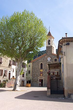
 Local church |
||
Saint-Martin-du-Var is a French commune in the Alpes-Maritimes in the region Provence-Alpes-Cote d'Azur . It belongs to the Arrondissement of Nice , the Canton of Tourrette-Levens and the Métropole Nice Côte d'Azur .
geography
Saint-Martin-du-Var is located in the French Maritime Alps at the mouth of the L 'Esteron river. The Var River runs along the western boundary of the municipality . Neighboring communities are:
- La Roquette-sur-Var in the north,
- Saint Blaise to the east,
- Carros in the south,
- Le Broc to the west and
- Gilette in the northwest.
The M6202 trunk road and the meter-gauge railway line Nice - Digne-les-Bains of the Chemins de fer de Provence run along the river valley .
history
The name Saint Martin goes back to a villa or country house from the Carolingian period, which was built by the Abbey of Saint Pons in Nice. Until 1860 the place was called Rochetta-San Martino and then until 1867 La Roquette-Saint Martin . The village has had its current name since then.
Large floods in the 1750s completely destroyed the settlement on the banks of the Var with its agricultural areas, so that the place had to be rebuilt at a higher point. During the first coalition war , a losing battle took place near Gilette in September 1792, in which the Piedmontese armed forces failed to push back the French revolutionary troops near Gilette.
In 1845 the fortifications on the left bank of the Var to protect against flooding were completed; Since 1883, Saint-Martin-du-Var has been accessible via the Nice – Digne-les-Bains narrow-gauge railway . In 1867 the two villages of La Roquette and Saint Martin and their cultivated areas were administratively separated from each other after a vote by the residents; you wanted to be independent. In 1944, during a German offensive against Levens between August 19 and 24 , several residents of Saint-Martin-du-Var were killed.
coat of arms
A blue bridge over a blue river is shown on a gold background. Above is a red flaming globe. The river symbol represents the river Var , the red flaming globe is to be understood as an attribute of Martin von Tours .
Population development
| year | 1962 | 1968 | 1975 | 1982 | 1990 | 1999 | 2008 | 2016 |
|---|---|---|---|---|---|---|---|---|
| Residents | 1,072 | 1,180 | 1,318 | 1,528 | 1,869 | 2,197 | 2,541 | 2,940 |
literature
- Le Patrimoine des Communes des Alpes-Maritimes . Flohic Editions, Volume 1, Paris 2000, ISBN 2-84234-071-X , pp. 470-475.
Web links
Individual evidence
- ↑ Website of the municipality of Saint-Martin-du-Var with information on the history and the coat of arms (accessed November 22, 2015) ( Memento of the original of November 22, 2015 in the Internet Archive ) Info: The archive link has been inserted automatically and has not yet been checked . Please check the original and archive link according to the instructions and then remove this notice.
