
Castillon (Alpes-Maritimes)
| Castillon | ||
|---|---|---|

|
|
|
| region | Provence-Alpes-Cote d'Azur | |
| Department | Alpes-Maritimes | |
| Arrondissement | Nice | |
| Canton | Menton | |
| Community association | Riviera Française | |
| Coordinates | 43 ° 50 ' N , 7 ° 28' E | |
| height | 275-1,289 m | |
| surface | 7.51 km 2 | |
| Residents | 367 (January 1, 2017) | |
| Population density | 49 inhabitants / km 2 | |
| Post Code | 06500 | |
| INSEE code | 06036 | |
France-2013-gb.jpg) Castillon in 2013 |
||

Castillon is a French commune in the Alpes-Maritimes in the region Provence-Alpes-Cote d'Azur . It belongs to the Arrondissement of Nice and the Canton of Menton . The residents call themselves the Castillonnais.
geography
The municipality lies on a foothill of the French Maritime Alps and borders on Sospel to the north, Castellar to the east, Menton and Sainte-Agnès to the south and Peille to the west .
history
There used to be a narrow-gauge railway line from Menton to Sospel via Castillon. Castillon was affected by a bombardment in the winter of 1944/45 .
Population development
| year | 1962 | 1968 | 1975 | 1982 | 1990 | 1999 | 2008 | 2014 |
|---|---|---|---|---|---|---|---|---|
| Residents | 82 | 97 | 55 | 79 | 187 | 282 | 342 | 380 |

The viaduct "Viaduc du Caramel", at that time still occupied by the Menton-Sospel railway line

The Viaduc du Carréi, which was also built for the railway line, around 1910

The former train station of Castillon
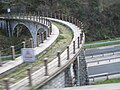
The viaducts, here the Viaduc du Carrei, have been preserved.

_Est.jpg)


literature
- Le Patrimoine des Communes des Alpes-Maritimes . Flohic Editions, Volume 2, Paris 2000, ISBN 2-84234-071-X , pp. 901-903.