
Saint-Dalmas-le-Selvage
| Saint-Dalmas-le-Selvage | ||
|---|---|---|

|
|
|
| region | Provence-Alpes-Cote d'Azur | |
| Department | Alpes-Maritimes | |
| Arrondissement | Nice | |
| Canton | Tourrette-Levens | |
| Community association | Nice Cote d'Azur | |
| Coordinates | 44 ° 17 ′ N , 6 ° 52 ′ E | |
| height | 1,280-2,916 m | |
| surface | 81.03 km 2 | |
| Residents | 118 (January 1, 2017) | |
| Population density | 1 inhabitant / km 2 | |
| Post Code | 06660 | |
| INSEE code | 06119 | |
 Saint-Dalmas-le-Selvage |
||

Saint-Dalmas-le-Selvage is a French commune in the Alpes-Maritimes in the region Provence-Alpes-Cote d'Azur . It belongs to the Arrondissement of Nice and the canton of Tourrette-Levens . She is also a member of the Métropole Nice Côte d'Azur municipal association .
geography
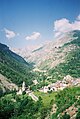
The community is located in the French Maritime Alps , around 90 kilometers from Nice in the Mercantour National Park . The Tinée rises in the north-west of the municipality . The neighboring municipalities are Jausiers in the north-west, Saint-Étienne-de-Tinée in the east, Entraunes in the south-west and Uvernet-Fours in the west. In addition to the main settlement at 1500 m , Saint-Dalmas-le-Selvage also includes the hamlets of La Pra at 1700, Bousieyas at 1960 and Le Camp de Fourches at 2300 m. The latter settlement was constructed in 1896 for military purposes and initially consisted of 26 barracks, which offered space for around 800 men.
Population development
| year | 1962 | 1968 | 1975 | 1982 | 1990 | 1999 | 2008 | 2016 |
|---|---|---|---|---|---|---|---|---|
| Residents | 133 | 152 | 151 | 121 | 114 | 123 | 132 | 122 |
Attractions
See: List of Monuments historiques in Saint-Dalmas-le-Selvage
Local panorama

Chapel of Sainte-Marguerite

Village church

Headwaters of the Tinée


literature
- Le Patrimoine des Communes des Alpes-Maritimes . Flohic Editions, Volume 2, Paris 2000, ISBN 2-84234-071-X , pp. 826-828.