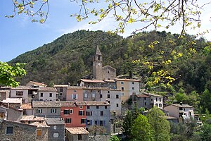
Malaussène
| Malaussène | ||
|---|---|---|

|
|
|
| region | Provence-Alpes-Cote d'Azur | |
| Department | Alpes-Maritimes | |
| Arrondissement | Nice | |
| Canton | Vence | |
| Community association | Alpes d'Azur | |
| Coordinates | 43 ° 56 ' N , 7 ° 8' E | |
| height | 154-1,468 m | |
| surface | 19.48 km 2 | |
| Residents | 311 (January 1, 2017) | |
| Population density | 16 inhabitants / km 2 | |
| Post Code | 06710 | |
| INSEE code | 06078 | |
 Malaussène |
||
Malaussène is a French commune in the Alpes-Maritimes in the region Provence-Alpes-Cote d'Azur . It belongs to the Arrondissement of Nice and the Canton of Vence . The residents call themselves Malaussénois.
geography
The community is located in the French Maritime Alps . The River Var forms the border with Utelle in the east, Tournefort in the northeast, Massoins in the north and not all of Villars-sur-Var in the west. The other neighboring communities are Pierrefeu in the southwest and Toudon , Tourette-du-Château and Revest-les-Roches in the south.
history
In the 13th century the settlement was called "Malauzena".
Population development
| year | 1962 | 1968 | 1975 | 1982 | 1990 | 1999 | 2008 | 2012 |
|---|---|---|---|---|---|---|---|---|
| Residents | 110 | 114 | 72 | 72 | 129 | 173 | 236 | 265 |
Attractions
See also: List of Monuments historiques in Malaussène
- Viaduct , 40 m high and 7 km long, built in 1774/75
- The Église de l'Assomption church , built in 1639
- The Chapelle des Pénitents blancs
- The Chapelle Saint-Roch dates back to 1674
- The Chapelle Saint-Louis-de-Gonzague
- The 17th century Chapelle Saint-Joseph
- Way of the Cross from 1737
- Mills for the production of oil and flour
- A fortress and a castle
- two grottos
literature
- Le Patrimoine des Communes des Alpes-Maritimes . Flohic Editions, Volume 2, Paris 2000, ISBN 2-84234-071-X , pp. 973-974.
Web links
Commons : Malaussène - collection of images, videos and audio files

