
La Penne
| La Penne | ||
|---|---|---|

|
|
|
| region | Provence-Alpes-Cote d'Azur | |
| Department | Alpes-Maritimes | |
| Arrondissement | Nice | |
| Canton | Vence | |
| Community association | Alpes d'Azur | |
| Coordinates | 43 ° 56 ' N , 6 ° 57' E | |
| height | 520-1,436 m | |
| surface | 18.08 km 2 | |
| Residents | 221 (January 1, 2017) | |
| Population density | 12 inhabitants / km 2 | |
| Post Code | 06260 | |
| INSEE code | 06093 | |

La Penne is a French commune with January 1, 2017 (As at 1 January 2017) in the department of Alpes-Maritimes in the region Provence-Alpes-Cote d'Azur . It belongs to the Arrondissement of Nice and the Canton of Vence . The residents call themselves Pennois .
geography
La Penne is located in the French Maritime Alps . The neighboring municipalities are Puget-Théniers in the north, Touët-sur-Var in the northeast, Ascros in the east, Saint-Antonin in the southeast, Cuébris in the south, Saint-Pierre and La Rochette in the west and Entrevaux (point of contact) in the northwest.
Population development
| year | 1962 | 1968 | 1975 | 1982 | 1990 | 1999 | 2008 | 2014 |
|---|---|---|---|---|---|---|---|---|
| Residents | 131 | 124 | 116 | 120 | 145 | 164 | 302 | 298 |
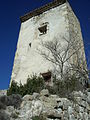
Pigeon tower
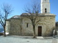
Saint-Pierre church


literature
- Le Patrimoine des Communes des Alpes-Maritimes . Flohic Editions, Volume 2, Paris 2000, ISBN 2-84234-071-X , pp. 719-722.
Web links
Commons : La Penne - collection of images, videos and audio files