
La Rochette (Alpes-de-Haute-Provence)
| La Rochette | ||
|---|---|---|

|
|
|
| region | Provence-Alpes-Cote d'Azur | |
| Department | Alpes-de-Haute-Provence | |
| Arrondissement | Castellane | |
| Canton | Castellane | |
| Community association | Alpes Provence Verdon | |
| Coordinates | 43 ° 55 ' N , 6 ° 53' E | |
| height | 637-1,505 m | |
| surface | 18.8 km 2 | |
| Residents | 70 (January 1, 2017) | |
| Population density | 4 inhabitants / km 2 | |
| Post Code | 06260 | |
| INSEE code | 04170 | |
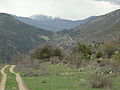
_-_Juillet_1990.JPG) La Rochette |
||

La Rochette is a French municipality with 70 inhabitants (at January 1, 2017) in the department of Alpes-de-Haute-Provence in the region Provence-Alpes-Cote d'Azur . It belongs to the canton of Castellane in the arrondissement of Castellane .
geography
The village is 850 m above sea level. The neighboring municipalities are Entrevaux in the north, Puget-Théniers (point of contact) and La Penne in the northeast, Saint-Pierre in the east, Sallagriffon in the southeast, Collongues in the south, Amirat in the southwest and Val-de-Chalvagne in the west.
Elevation
- Pic de Salomon, 1196 m
Population development
| year | 1962 | 1968 | 1975 | 1982 | 1990 | 1999 | 2008 | 2012 |
|---|---|---|---|---|---|---|---|---|
| Residents | 90 | 74 | 66 | 41 | 48 | 53 | 57 | 62 |
Attractions
- Saint-Saturnib Chapel
- Chapelle d'Avenos, dated 1815, privately owned
- Fallen memorial
- Notre-Dame-des-Parans church
- Away
Col du Trebuchet

Saint-Saturnin Chapel
.JPG)
-proche.JPG)
Web links
Commons : La Rochette - collection of images, videos and audio files