
Thorame-Haute
| Thorame-Haute | ||
|---|---|---|

|
|
|
| region | Provence-Alpes-Cote d'Azur | |
| Department | Alpes-de-Haute-Provence | |
| Arrondissement | Castellane | |
| Canton | Castellane | |
| Community association | Alpes Provence Verdon | |
| Coordinates | 44 ° 6 ′ N , 6 ° 33 ′ E | |
| height | 971-2,693 m | |
| surface | 108.35 km 2 | |
| Residents | 240 (January 1, 2017) | |
| Population density | 2 inhabitants / km 2 | |
| Post Code | 04170 | |
| INSEE code | 04219 | |
 Thorame-Haute |
||

Thorame-Haute is a French municipality with 240 inhabitants (at January 1, 2017) in the department of Alpes-de-Haute-Provence in the region Provence-Alpes-Cote d'Azur . It belongs to the canton of Castellane in the arrondissement of Castellane . The residents call themselves Thoramiens , Ondraincs , Collaincs or Peyrescans .
geography
Thorame-Haute is located in the French Maritime Alps and is crossed by the Verdon River. The neighboring municipalities are: Beauvezer in the north, Colmars in the northeast, Castellet-lès-Sausses in the east, Méailles in the southeast, Allons in the south and La Mure-Argens and Thorame-Basse in the west. Thorame-Haute station is served by the meter-gauge railway line Nice - Digne-les-Bains of the Chemins de fer de Provence . In 2007 La Colle-Saint-Michel was incorporated into Thorame-Haute. In La Colle-Saint-Michel there is a winter sports area with trails totaling around 35 kilometers.
Population development
| year | 1962 | 1968 | 1975 | 1982 | 1990 | 1999 | 2008 | 2012 |
|---|---|---|---|---|---|---|---|---|
| Residents | 210 | 206 | 191 | 187 | 206 | 174 | 228 | 232 |

Thorame-Haute train station
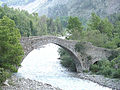
Pont du Moulin, a bridge over the Verdon
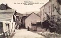
Thorame-Haute on an old postcard


Architectural monuments
See: List of Monuments historiques in Thorame-Haute