
Verdon
| Verdon | ||
 Verdon Gorge |
||
| Data | ||
| Water code | FR : X2-0200 | |
| location | France , Provence-Alpes-Cote d'Azur region | |
| River system | Rhône | |
| Drain over | Durance → Rhône → Mediterranean | |
| source | near La Foux-d'Allos , in the municipality of Allos 44 ° 19 ′ 18 ″ N , 6 ° 32 ′ 51 ″ E |
|
| Source height | approx. 2460 m | |
| muzzle | below Vinon-sur-Verdon , but already in the municipality of Saint-Paul-lès-Durance , in the Durance coordinates: 43 ° 43 ′ 9 ″ N , 5 ° 44 ′ 59 ″ E 43 ° 43 ′ 9 ″ N , 5 ° 44 ′ 59 ″ E |
|
| Mouth height | approx. 255 m | |
| Height difference | approx. 2205 m | |
| Bottom slope | approx. 13 ‰ | |
| length | approx. 167 km | |
| Catchment area | 2294 km² | |
| Discharge at the Vinon-sur-Verdon A Eo gauge : 1820 km² |
MQ Mq |
27 m³ / s 14.8 l / (s km²) |
| Left tributaries | see adjacent table | |
| Right tributaries | see adjacent table | |
The Verdon ( Virdones in the Middle Ages ) is a river in France that runs in the Provence-Alpes-Côte d'Azur region . It has its source in the French Maritime Alps , in the municipality of Allos . Its source is located northwest of the Col d'Allos , on the southern flank of the Tête de la Sestrière summit (2575 m). The river generally drains south-west and flows into the Durance as a left tributary after 167 kilometers below Vinon-sur-Verdon , but already in the municipality of Saint-Paul-lès-Durance , in the backwater of the Barrage de Cadarache . On its way, the Verdon crosses the Alpes-de-Haute-Provence and Var departments , the borders of which it forms in large parts of its course. In the estuary section it also touches the Vaucluse and Bouches-du-Rhône departments .
Places on the river
Hydrology
In the course of the Verdon, a total of five dams were built between 1923 and 1975 on Lac de Castillon , Lac de Chaudanne , Lac de Sainte-Croix , Retenue de Quinson and Lac d'Esparron, not only for the purpose of generating energy. The most famous and largest reservoir is located behind a dam built between 1971 and 1974 south of Sainte-Croix . The Lac de Sainte-Croix created by its construction covers 21.80 km² and absorbs up to 761 million m³ of water.
Tributaries
|
Left tributaries: |
Right tributaries:
|
Attractions
The entire middle and lower reaches of the river lie in the Verdon Regional Nature Park . The most scenic section is between the town of Castellane and the Lac de Sainte-Croix . There, over a length of 21 km, the Verdon forms the Verdon Gorge ( Gorges du Verdon , Grand Canyon du Verdon ), one of the mightiest and most impressive gorges in Europe. The most spectacular part of the gorge is accompanied by a road, partly on a higher level through the corniche sublime gorge or on the high altitudes. There are always very beautiful sections on this route with deep views into and over the valley, but only a few opportunities to descend. Very suitable for white water paddling , free climbing and adventure hikes. In France, this climbing style culture is said to have been the first to gain a foothold here.
Near the river is the prehistoric village of Quinson .
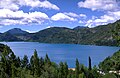
View of the Lac de Castillon from St. Julien

Entrance to the gorge from the bridge on Lac de Sainte-Croix

Inside the Verdon Gorge

The Lac de Sainte-Croix with the Castle of Aiguines

Lac de Chaudanne


Web links
Individual evidence
- ↑ a b geoportail.fr (1: 16,000)
- ↑ a b c The information on the length of the river is based on the information about the Verdon at SANDRE (French), accessed on March 14, 2011, rounded to full kilometers.
- ↑ hydro.eaufrance.fr (station: X2812010 , option: Synthèse )