
Verdon Regional Natural Park

The Verdon Regional Nature Park ( French Parc naturel régional du Verdon ) is located in the French region of Provence-Alpes-Côte d'Azur and includes parts of the Alpes-de-Haute-Provence and Var departments . The nature park, founded in 1997, has an area of around 193,000 hectares. 46 municipalities with around 20,000 inhabitants form the park, three cities on the edge of the park are associated as access points. They are:
The park administration is based in Valx Castle in the municipality of Moustiers-Sainte-Marie ( 43 ° 50 ′ N , 6 ° 14 ′ E, ).
Landscapes
The area of the nature park is located in the Provencal Prealps , in a transition zone between Provence and the foothills of the Western Alps . It encompasses a diverse, richly indented landscape in the river Verdon catchment area , which rises from around 500 meters in the west to an altitude of around 1800 meters in the east and north.
The main areas of the park are:
- The Valensole plateau
The plateau lies in the north-western area of the nature park. From a geological point of view, it is a molasse basin, which has a layer of debris several hundred meters thick, which was created as a result of the mountain formation . In the center of this plateau lies the city of Valensole . Durum wheat and lavandin , a natural hybrid of real lavender and Speik lavender for the extraction of essences and essential oils , are mainly grown here . The former Gallo-Roman culture has left traces everywhere: z. B. Roman temple , basilica and baptistery in Riez , thermal baths in Gréoux-les-Bains .
- The hills of the Haut-Var
The hilly landscape is located in the southwestern part of the nature park and belongs to the Var department. In this area, forests and agricultural land alternate. The main focus is on the production of olive oil , but the black truffle also gives the population a not insignificant additional income. Life is contemplative, in the shade of the plane trees people like to indulge in a game of pétanque . In contrast to the idyllic landscape, the area has a particularly militant history: Here the rebels took up arms to defeat the republic in 1851 against the coup d'état of Napoleon III. defend, in 1940 it was a stronghold of the Resistance movement. The Resistance Museum in Aups documents this part of local history.
- Lakes and gorges on the lower reaches of the Verdon
The area is centrally located in the nature park and extends on the lower reaches of the Verdon river, roughly between the towns of Montagnac-Montpezat and Esparron-de-Verdon . The gorges are cut around 100 to 200 meters deep and are interrupted by small reservoirs ( Retenue de Quinson , Lac d'Esparron ). Holm oaks and holm oaks make up the main part of the vegetation , they have long been the raw material supplier for the production of charcoal . The clean water is the basis for a large and diverse population of fish . Since the landscape here was less hostile to life than in the large canyons higher up, the lower gorges of the Verdon were populated very early: the people of prehistory settled here in a multitude of caves and grottos . This period is documented in the Museum of Prehistory in Quinson .
- The reservoir "Lac de Sainte-Croix"
In its central section, the Verdon River was dammed into a large lake in 1974, the Lac de Sainte-Croix . It has an area of about 2200 hectares and forms an interesting contrast to the surrounding mountain landscape with its turquoise water color. The reservoir is not only used for power generation and tourism on the waterfront, but also for drinking water supply in large parts of Provence . During the damming, the village of Les Salles-sur-Verdon was flooded and rebuilt above the water level. Four bridges over the river have also disappeared in the floods, among them a Romanesque bridge built south of Sainte-Croix-du-Verdon on the Roman road from Fréjus to Riez , and to the north the medieval bridge of Aiguines . A 17th century tradition in this area is the production of faience , which is documented in the Faience Museum of Moustiers-Sainte-Marie . The management of the natural park, the so-called Maison du Parc, is also located here .
- The Verdon Gorge
This landscape, located in the center of the natural park, includes the greatest tourist attraction, the Verdon Gorge . It stretches along the middle reaches of the Verdon river, between the town of Castellane and the Lac de Sainte-Croix reservoir. The imposing gorge is between six and 100 meters wide at the bottom, the opposite flanks are 200 to 1500 meters apart and the depth varies between 250 and 700 meters. A population of vultures was resettled in this natural setting . The sparse vegetation consists mainly of boxwood , which in the past was also collected by brave pickers using the abseiling technique . Today the box tree pickers have been replaced by climbers , and a large number of tourists follow the path laid out in 1905 at the bottom of the gorge or use the river for rafting trips . The most beautiful views are from the gorge flanks, from which there are magnificent views near the towns of Rougon and La Palud-sur-Verdon . But also south of the gorge, on the D71, on the connection between Aiguines and Comps-sur-Artuby , there is easy access to this natural monument. However, the descent to the bottom of the gorge is only possible in a few places and with the appropriate equipment and fitness .
- The Artuby River Basin
This landscape is located in the southeast of the natural park and is in the Var department. It includes the catchment area of the Artuby River and the Jabron, which runs parallel to it, and is bounded in the south by the Plan de Canjuers plateau, a karst plateau on which the military training area Camp militaire de Canjuers is located. In the valleys, which are often separated by high rocky reliefs, forest areas cover around 60% of the soil. The forest provides the basis for hunting and mushroom picking , but is also used for the production of renewable energy from biomass . The sheep is relevant here. The main town is Comps-sur-Artuby .
- Lakes and mountains on the upper reaches of the Verdon
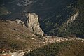
In the north-east of the nature park is the area with the highest elevations on the upper reaches of the Verdon river. Three prominent peaks mark the transition to the alpine area. These are the Montdenier (1750 m), Mont Chiran (1905 m) and the Mourre de Chanier (1930 m). Here the Verdon has dug a wide and fertile valley where the agricultural areas and populated areas are concentrated. The historic town of Castellane, for example, was built between a 200 meter high rock and the banks of the Verdon. Further north is Saint-André-les-Alpes , a stop for the pine-cone train that runs from Nice on the Nice – Digne-les-Bains railway to Digne-les-Bains . Two reservoirs shape the valley: Lac de Castillon and Lac de Chaudanne .
See also
Web links
- Verdon Regional Nature Park (French)
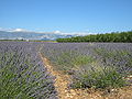
Lavender fields on the Valensole plateau

The city of Aups
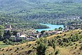
Esparron-de-Verdon and the Lac d'Esparron

The Lac de Sainte-Croix with the Castle of Aiguines

View of the Verdon Gorge

On the hiking trail in the Verdon Gorge

Mouth of the Verdon Gorge into the Lac de Sainte-Croix

Sheep at Plan de Canjuers
The rock of Castellane

The Mourre de Chanier as seen from Quinson

Station of the pine cone train in Saint-André-les-Alpes

Lac de Castillon in winter

Lac de Castillon, view towards Barrage (dam)


