Valensole
| Valensole | ||
|---|---|---|

|
|
|
| region | Provence-Alpes-Cote d'Azur | |
| Department | Alpes-de-Haute-Provence | |
| Arrondissement | Forcalquier | |
| Canton | Valensole | |
| Community association | Durance-Luberon-Verdon agglomeration | |
| Coordinates | 43 ° 50 ′ N , 5 ° 59 ′ E | |
| height | 290-651 m | |
| surface | 127.77 km 2 | |
| Residents | 3,204 (January 1, 2017) | |
| Population density | 25 inhabitants / km 2 | |
| Post Code | 04210 | |
| INSEE code | 04230 | |
| Website | http://valensole.fr/ | |
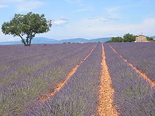
 View of Valensole |
||
Valensole (from the Latin Valentiola , first mentioned in 909) is a French commune with 3204 inhabitants (as of January 1, 2017) in the Alpes-de-Haute-Provence department in the Provence-Alpes-Côte d'Azur region .
geography
location
Valensole is one of the largest French municipalities in terms of area. The village lies in the valley of the Ruisseau Notre-Dame on a plateau of the mountainous Provence and is surrounded by lavender and almond trees as well as wheat fields , which are the main source of income with tourism . The climatic health resort of Valensole is located in the Verdon Regional Nature Park . The municipality includes the hilly landscape northwest of the village to the rivers L'Asse in the north and Durance in the west.
geology
The Valensole plateau is about 580 m above sea level. NN and is formed by mighty river deposits, which consist of Nagelfluh .
Neighboring communities
|
|
Marseille is 90 km away.
coat of arms
|
Description of coat of arms : Background azure with the capital letter V in gold and crowned by a golden sun |
history
The Valensole area was already inhabited in ancient times. The Roman Via Domitia led through the area.
In 990 the Cluny Abbey established a priory in Valensole. In the 11th century, a castle was built on the site that is now called La Moutte . One property belonged to the St-Victor monastery in Marseille . Important regional markets have been held in the small town of Valensole since 1282.
On July 1, 1965, a UFO is said to have landed near Valensole. The incident caused quite a stir at the time. A corresponding memorial was erected at the site of the supposed event.
Population development
| year | 1962 | 1968 | 1975 | 1982 | 1990 | 1999 | 2006 | 2018 |
| Residents | 1,712 | 1,791 | 1,721 | 1,944 | 2,202 | 2,334 | 3.224 | 3,228 |
| Sources: Cassini and INSEE | ||||||||
Culture and sights
Regular events
The highlights of the summer are the lavender festival ( Fête de la lavande ) and the durum wheat and pasta festival ( Fête des pâtes et du blé ).
Buildings
Valensole is a typical Provencal village with houses from the past centuries. The Grande Fontaine , the main 17th century fountain on the market square, has been classified as a Monument historique since 1962 . Individual parts of the adjacent church of Saint-Denis from the 11th century are also registered as Monument historique.
A bee museum and the truffle house are also worth seeing.
See also: List of Monuments historiques in Valensole
traffic
The road from Valensole to the town of Manosque runs on the Manosque bridge over the Durance.
Born in Valensole
- Maiolus (910–994), nobleman, priest, Benedictine and abbot of Cluny for forty years
- Gaspard Jean-Baptiste de Brunet (1734–1793), general during the French Revolution, executed
- Pierre de Villeneuve (1763–1806), French vice admiral, commander in the Battle of Trafalgar


