
Entrepierres
| Entrepierres | ||
|---|---|---|

|
|
|
| region | Provence-Alpes-Cote d'Azur | |
| Department | Alpes-de-Haute-Provence | |
| Arrondissement | Forcalquier | |
| Canton | Sisteron | |
| Community association | Sisteronais-Buëch | |
| Coordinates | 44 ° 13 ′ N , 6 ° 0 ′ E | |
| height | 455-1,444 m | |
| surface | 47.79 km 2 | |
| Residents | 379 (January 1, 2017) | |
| Population density | 8 inhabitants / km 2 | |
| Post Code | 04200 | |
| INSEE code | 04075 | |
 Mairie Entrepierres |
||

Entrepierres is a French municipality with 379 inhabitants (at January 1, 2017) in the department of Alpes-de-Haute-Provence in the region Provence-Alpes-Cote d'Azur . It belongs to the Arrondissement of Forcalquier and the Canton of Sisteron . The residents call themselves the Interpétasiens .
geography
Entrepierres is crossed by the Riou de Jabron and Vanson rivers . Both flow outside the municipality mark in the Durance , which touches the municipality in the southwest. The neighboring communities are
- Saint-Geniez in the north,
- Le Castellard-Mélan in the east,
- Thoard in the southeast,
- Sourribes and Salignac in the south,
- Peipin in the southwest,
- Sisteron in the west,
- Valernes in the northwest.
In addition to the main settlement, Entrepierres also includes the hamlets of Saint-Symphorien and Vilhosc. Both have been mentioned as Sanctus Symphorianus and Vilioscum from the 11th century.
Population development
| year | 1962 | 1968 | 1975 | 1982 | 1990 | 1999 | 2008 | 2012 |
|---|---|---|---|---|---|---|---|---|
| Residents | 135 | 114 | 136 | 163 | 205 | 312 | 389 | 396 |
Attractions
- Vilhosc Priory Farm, Monument historique
- Pont de la rein Jeanne, a bridge over the Vanson , monument historique near the hamlet of Saint-Symphorien, dates to the 17th and 18th centuries, 10 meters long and 2.17 m wide
- Château de Briasc, dates to the 17th century
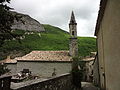
- Saint-Marc church, dates back to the 17th century
- Saint-Pierre des Nauds chapel
- Saint-Gervais church
- Saint-Gervais-et-Saint-Protais church in Vilhosc
- Saint-Saturnin de Mézien church
See also: List of Monuments historiques in Entrepierres

Château de Briasc

Pont de la rein Jeanne
Saint-Marc church
-2.JPG)

.JPG)