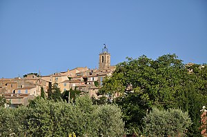
Puimoisson
| Puimoisson | ||
|---|---|---|

|
|
|
| region | Provence-Alpes-Cote d'Azur | |
| Department | Alpes-de-Haute-Provence | |
| Arrondissement | Forcalquier | |
| Canton | Riez | |
| Community association | Durance-Luberon-Verdon agglomeration | |
| Coordinates | 43 ° 52 ' N , 6 ° 8' E | |
| height | 567-781 m | |
| surface | 35.44 km 2 | |
| Residents | 723 (January 1, 2017) | |
| Population density | 20 inhabitants / km 2 | |
| Post Code | 04410 | |
| INSEE code | 04157 | |
 Puimoisson |
||
Puimoisson is a municipality with 723 inhabitants (as of January 1, 2017) in southern France . It belongs to the Provence-Alpes-Côte d'Azur region , the Alpes-de-Haute-Provence department , the Forcalquier arrondissement and the Riez canton .
geography
The place is located at 698 m on the Plateau de Valensole. 1200 hectares of the municipality mark are forested. The neighboring municipalities are Saint-Julien-d'Asse and Bras-d'Asse in the north, Saint-Jurs and Moustiers-Sainte-Marie in the east, Roumoules in the south and Riez and Brunet in the west.
Population development
| year | 1962 | 1968 | 1975 | 1982 | 1990 | 1999 | 2009 | 2016 |
|---|---|---|---|---|---|---|---|---|
| Residents | 473 | 508 | 491 | 511 | 511 | 551 | 720 | 739 |
Attractions
- Saint-Apollinaire Chapel, Monument historique
- Saint-Michel church, monument historique
- Château du Pas-de-Laval
- Commanderie des Hospitaliers
- Notre-Dame-de-Bellevue chapel
- Aérodrome de Puimoisson glider airfield
Personalities
- Durandus von Mende (around 1230–1296), Bishop of Mende, liturgist, born in Puimoisson.
- Henri Jordany (1798–1887), Bishop of Fréjus, born in Puimoisson.
Web links
Commons : Puimoisson - collection of images, videos and audio files

