
Saint-Etienne-les-Orgues
| Saint-Etienne-les-Orgues | ||
|---|---|---|

|
|
|
| region | Provence-Alpes-Cote d'Azur | |
| Department | Alpes-de-Haute-Provence | |
| Arrondissement | Forcalquier | |
| Canton | Forcalquier | |
| Community association | Pays Forcalquier and Montagne de Lure | |
| Coordinates | 44 ° 3 ' N , 5 ° 47' E | |
| height | 549-1,825 m | |
| surface | 48.42 km 2 | |
| Residents | 1,296 (January 1, 2017) | |
| Population density | 27 inhabitants / km 2 | |
| Post Code | 04230 | |
| INSEE code | 04178 | |

Saint-Etienne-les-Orgues is a French commune with 1,296 inhabitants (at January 1, 2017) in the department of Alpes-de-Haute-Provence and the region Provence-Alpes-Cote d'Azur . It belongs to the canton of Forcalquier and the Arrondissement Forcalquier .
geography
The municipality borders:
- in the north at Saint-Vincent-sur-Jabron and Noyers-sur-Jabron ,
- to the east at Cruis , Montlaux and Revest-Saint-Martin ,
- in the southeast at Fontienne ,
- in the south at Forcalquier (point of contact),
- in the southwest at Ongles ,
- to the west with Lardiers .
The village is located at 687 m in the area of the Montagne de Lure .
Population development
| year | 1962 | 1968 | 1975 | 1982 | 1990 | 1999 | 2008 | 2012 |
|---|---|---|---|---|---|---|---|---|
| Residents | 477 | 478 | 561 | 679 | 1091 | 873 | 1,222 | 1,234 |
Attractions
- Notre-Dame-de-Lure Abbey , a monument historique at about 1200 m
- Château du Truyas
- Château du Tondu
- Saint-Etienne church
- Chapelle Saint-Joseph
- Chapelle du Vigneau

memorial
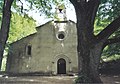
Notre-Dame-de-Lure abbey
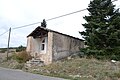
Saint Joseph Chapel

Saint-Etienne church


Web links
Commons : Saint-Étienne-les-Orgues - Collection of images, videos and audio files