
Niozelles
| Niozelles | ||
|---|---|---|

|
|
|
| region | Provence-Alpes-Cote d'Azur | |
| Department | Alpes-de-Haute-Provence | |
| Arrondissement | Forcalquier | |
| Canton | Forcalquier | |
| Community association | Pays Forcalquier and Montagne de Lure | |
| Coordinates | 43 ° 56 ' N , 5 ° 50' E | |
| height | 354-603 m | |
| surface | 10.47 km 2 | |
| Residents | 271 (January 1, 2017) | |
| Population density | 26 inhabitants / km 2 | |
| Post Code | 04300 | |
| INSEE code | 04138 | |

Niozelles is a commune with 271 inhabitants (at January 1, 2017) in the Alpes-de-Haute-Provence in the region Provence-Alpes-Cote d'Azur . It belongs to the Arrondissement Forcalquier and the Canton Forcalquier .
geography
The municipality is located around five kilometers from Forcalquier in the Beveron valley , a tributary of the Lauzon . It borders on Pierrerue to the north, Lurs and La Brillanne to the east, Villeneuve to the south and Forcalquier to the west. 476 hectares of the municipality mark are forested.
population
| 1962 | 1968 | 1975 | 1982 | 1990 | 1999 | 2007 | 2012 |
|---|---|---|---|---|---|---|---|
| 138 | 125 | 106 | 111 | 170 | 199 | 233 | 272 |
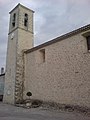
Saint-Etienne Martyr church

lock


Web links
Commons : Niozelles - collection of images, videos and audio files