Montfuron
| Montfuron | ||
|---|---|---|

|
|
|
| region | Provence-Alpes-Cote d'Azur | |
| Department | Alpes-de-Haute-Provence | |
| Arrondissement | Forcalquier | |
| Canton | Manosque-1 | |
| Community association | Durance-Luberon-Verdon agglomeration | |
| Coordinates | 43 ° 50 ′ N , 5 ° 42 ′ E | |
| height | 373-706 m | |
| surface | 18.88 km 2 | |
| Residents | 210 (January 1, 2017) | |
| Population density | 11 inhabitants / km 2 | |
| Post Code | 04110 | |
| INSEE code | 04128 | |
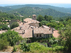
 Montfuron with the Notre-Dame-et-Saint-Elzéar church |
||
Montfuron is a municipality with 210 inhabitants (as of January 1, 2017) in southern France . It belongs to the Provence-Alpes-Côte d'Azur region , the Alpes-de-Haute-Provence department , the Forcalquier arrondissement and the Manosque-1 canton . The residents call themselves Montfuronnais . The municipality borders on Villemus to the northeast, Manosque to the east, Pierrevent to the southeast, La Bastide-des-Jourdans to the southwest and Montjustin to the northwest .
Population development
| year | 1962 | 1968 | 1975 | 1982 | 1990 | 1999 | 2005 | 2012 |
|---|---|---|---|---|---|---|---|---|
| Residents | 48 | 86 | 79 | 156 | 149 | 166 | 189 | 204 |
Attractions
- Saint-Elzéar Chapel, Monument historique
Web links
Commons : Montfuron - collection of images, videos and audio files

