
Céreste
| Céreste | ||
|---|---|---|

|
|
|
| region | Provence-Alpes-Cote d'Azur | |
| Department | Alpes-de-Haute-Provence | |
| Arrondissement | Forcalquier | |
| Canton | Reillanne | |
| Community association | Pays d'Apt-Luberon | |
| Coordinates | 43 ° 51 ' N , 5 ° 35' E | |
| height | 370-971 m | |
| surface | 32.54 km 2 | |
| Residents | 1,199 (January 1, 2017) | |
| Population density | 37 inhabitants / km 2 | |
| Post Code | 04280 | |
| INSEE code | 04045 | |
 Mairie Céreste |
||

Céreste is a French commune with 1,199 inhabitants (at January 1, 2017) in the department of Alpes-de-Haute-Provence in the region Provence-Alpes-Cote d'Azur . It belongs to the canton of Reillanne in the Forcalquier arrondissement . The residents call themselves the Cerestain .
geography
The neighboring municipalities are Sainte-Croix-à-Lauze in the north, Reillanne and Montjustin in the east, Vitrolles-en-Lubéron in the south, Peypin-d'Aigues in the southwest and Saint-Martin-de-Castillon and Viens in the west. 1612 hectares of the parish are forested. The Route Nationale 100 runs through Céreste .
Population development
| year | 1962 | 1968 | 1975 | 1982 | 1990 | 1999 | 2008 | 2012 |
|---|---|---|---|---|---|---|---|---|
| Residents | 632 | 757 | 832 | 862 | 950 | 1,036 | 1,208 | 1,242 |
Attractions
- Roman Church, Monument historique
- Maison médiévale, a house from the 13th century, monument historique
- Carluc Priory
- Saint-Georges Chapel
See also: List of the Monuments historiques in Céreste
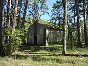
Saint-Georges Chapel

Roman bridge

Maison médiévale, medieval house


Carluc Priory
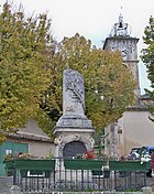
Fallen memorial

