
La Rochegiron
| La Rochegiron | ||
|---|---|---|

|
|
|
| region | Provence-Alpes-Cote d'Azur | |
| Department | Alpes-de-Haute-Provence | |
| Arrondissement | Forcalquier | |
| Canton | Reillanne | |
| Community association | Haute-Provence Pays de Banon | |
| Coordinates | 44 ° 5 ' N , 5 ° 39' E | |
| height | 760-1,533 m | |
| surface | 30.11 km 2 | |
| Residents | 100 (January 1, 2017) | |
| Population density | 3 inhabitants / km 2 | |
| Post Code | 04150 | |
| INSEE code | 04169 | |

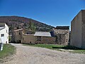
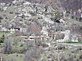
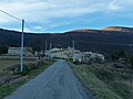
Rochegiron is a French commune of 100 people (at January 1, 2017) in the department of Alpes-de-Haute-Provence in the region Provence-Alpes-Cote d'Azur . It belongs to the canton of Reillanne in the Forcalquier arrondissement . The residents call themselves the Rochegironais .
geography
Rochegiron is located in the French Maritime Alps and borders on Montfroc to the north, Châteauneuf-Miravail to the northeast, L'Hospitalet and Saumane to the east, Banon to the south and Redortiers to the west . The village center is at 800 m . 1029 hectares of the municipality mark are forested.
Surveys
Rochegiron surveys are:
- Roche de la Vierge ( 938 m )
- Meynière ( 1029 m )
- Coulet ( 1190 m )
- Gardette ( 1191 m )
- Défens ( 1403 m )
- Tréboux ( 1535 m )
Population development
| year | 1962 | 1968 | 1975 | 1982 | 1990 | 1999 | 2008 | 2012 |
|---|---|---|---|---|---|---|---|---|
| Residents | 83 | 68 | 76 | 92 | 94 | 92 | 108 | 97 |
District of Jonquet
District of Vière
District of Saint Pancrace

Town Hall ( Mairie )


Web links
Commons : La Rochegiron - Collection of images, videos and audio files