Bras-d'Asse
| Bras-d'Asse | ||
|---|---|---|

|
|
|
| region | Provence-Alpes-Cote d'Azur | |
| Department | Alpes-de-Haute-Provence | |
| Arrondissement | Digne-les-Bains | |
| Canton | Riez | |
| Community association | Provence-Alpes agglomeration | |
| Coordinates | 43 ° 56 ' N , 6 ° 8' E | |
| height | 455-812 m | |
| surface | 26.1 km 2 | |
| Residents | 568 (January 1, 2017) | |
| Population density | 22 inhabitants / km 2 | |
| Post Code | 04270 | |
| INSEE code | 04031 | |
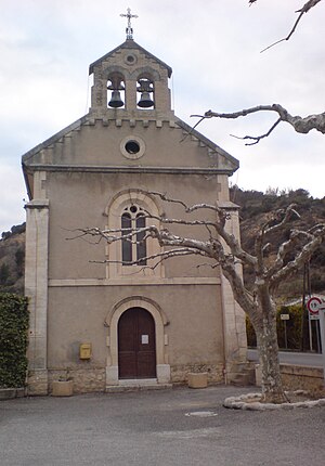
 Saint-Nicolas-de-Myre church |
||
Bras-d'Asse is a french commune with 568 inhabitants (at January 1, 2017) in the department of Alpes-de-Haute-Provence in the region Provence-Alpes-Cote d'Azur . It belongs to the canton of Riez in the Digne-les-Bains arrondissement . The inhabitants call themselves Bras-d'Assiens .
geography
In addition to the main settlement, Bras-d'Asse also includes the hamlets of Les Orésonnis and La Bégude blanche. Approximately 1330 hectares of the parish are forested. The village is passed by the Asse river , which takes in the Torrent de Saint-Jeannet there. The neighboring municipalities are Saint-Jeannet in the north, Estoublon in the east, Saint-Jurs in the southeast, Puimoisson in the south and Saint-Julien-d'Asse in the west.
Population development
| year | 1962 | 1968 | 1975 | 1982 | 1990 | 1999 | 2008 | 2012 |
|---|---|---|---|---|---|---|---|---|
| Residents | 324 | 352 | 331 | 318 | 378 | 395 | 498 | 560 |
Attractions
- former village
- Castle ruins
- former church of Saint-Nicolas-de-Myre from 1657; the successor building of the same name was built between 1903 and 1905
- Notre-Dame church in the La Bégude district
- Saint-Jean-Baptiste chapel from 1908, privately owned in La Bégude
Web links
Commons : Bras-d'Asse - Collection of images, videos and audio files


