Peyruis
| Peyruis | ||
|---|---|---|

|
|
|
| region | Provence-Alpes-Cote d'Azur | |
| Department | Alpes-de-Haute-Provence | |
| Arrondissement | Digne-les-Bains | |
| Canton | Château-Arnoux-Saint-Auban | |
| Community association | Provence-Alpes agglomeration | |
| Coordinates | 44 ° 2 ' N , 5 ° 56' E | |
| height | 381-740 m | |
| surface | 23.23 km 2 | |
| Residents | 2,858 (January 1, 2017) | |
| Population density | 123 inhabitants / km 2 | |
| Post Code | 04310 | |
| INSEE code | 04149 | |
| Website | www.peyruis.fr | |
 Peyruis |
||
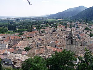
Peyruis ( Occitan : Peirueis ) is a commune with 2,858 inhabitants (as of January 1 2017) in the department of Alpes-de-Haute-Provence in the region Provence-Alpes-Cote d'Azur . Peyruis belongs to the arrondissement of Digne-les-Bains and the canton of Château-Arnoux-Saint-Auban . The inhabitants are called Peyruisiens .
geography
Peyruis is located on the right bank of the Durance River on the Massif de la Sainte-Baume ridge . Peyruis is surrounded by the neighboring communities of Mallefougasse-Augès in the north and north-west, Montfort in the north and north-east, Les Mées in the east and south-east, Ganagobie in the south and south-west, Sigonce in the south-west and Montlaux in the west.
The A51 autoroute and the former national route 96 run through the municipality .
Population development
| year | 1831 | 1846 | 1861 | 1876 | 1891 | 1906 | 1926 | 1946 | 1962 | 1968 | 1975 | 1982 | 1990 | 1999 | 2006 | 2011 |
| Residents | 868 | 851 | 774 | 829 | 779 | 719 | 616 | 797 | 1,343 | 1,604 | 1,627 | 1,699 | 2,036 | 2,217 | 2,438 | 2,767 |
Attractions
- Castle ruins from the 12th century
- Old Jewish quarter
- Saint-Roch church from the 11th century
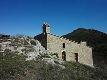
- Saint-Nicolas chapel

