
Massif de la Sainte-Baume


The Massif de la Sainte-Baume is a mountain ridge that extends in the south of France between the Bouches-du-Rhône and Var departments . Its highest point, the Joug de l'Aigle , reaches 1147 meters.
geology
The Massif de la Sainte-Baume is a folded mountain range . Like the Folding of the Pyrenees in the Tertiary , its geological origin is the collision of the Iberian Peninsula with the European continent around 50 to 100 million years ago . The Mediterranean mountain climate with its humid and mild winters makes the mountains one of the most important water reservoirs in the region and the headwaters of numerous rivers. Here spring Huveaune , VEDE , Peyruis , Gaudin , Caramy , Issole , Gapeau and Fauge . In addition, important underground waterways run through the area.
Flora and fauna
Red beech and oak forests determine the landscape of the massif and provide a habitat for characteristic flora and fauna, which represents the transition from the forests of the Mediterranean region to the alpine forests on the middle level. It is home to numerous rare and endangered species of beetle and the northernmost representatives of the Provencal sandwort .
Pilgrimage
According to an old French legend, Mary Magdalene came into the country via Saintes-Maries-de-la-Mer and proselytized Provence. She spent the last 30 years of her life as a hermit in a cave, La Sainte-Baume (the Provencal word baumo means cave ), after which the mountains are named. The cave has been an important place of pilgrimage since the Middle Ages. It is located below the Saint-Pilon in the municipality of Plan-d'Aups-Sainte-Baume .
photos
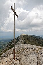
Summit with a summit cross
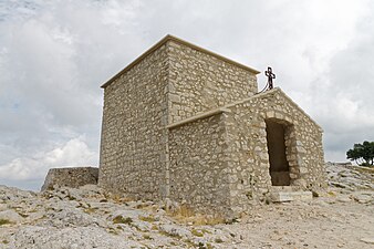
Chapelle du Saint-Pilon on the ridge

View to the northeast

View to the northwest

Holy Cave of Mary Magdalene


Web links
Coordinates: 43 ° 19 ' N , 5 ° 45' E