Plan-d'Aups-Sainte-Baume
| Plan-d'Aups-Sainte-Baume | ||
|---|---|---|

|
|
|
| region | Provence-Alpes-Cote d'Azur | |
| Department | Var | |
| Arrondissement | Brignoles | |
| Canton | Saint-Cyr-sur-Mer | |
| Community association | Communauté de communes Sainte Baume-Mont Aurélien | |
| Coordinates | 43 ° 20 ' N , 5 ° 43' E | |
| height | 510-1,148 m | |
| surface | 24.91 km 2 | |
| Residents | 2,158 (January 1, 2017) | |
| Population density | 87 inhabitants / km 2 | |
| Post Code | 83640 | |
| INSEE code | 83093 | |
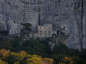
 Sanctuaire de la Sainte-Baume pilgrimage site |
||
Plan-d'Aups-Sainte-Baume is a French commune in the department of Var in the region Provence-Alpes-Cote d'Azur . It belongs to the Arrondissement of Brignoles and the canton of Saint-Cyr-sur-Mer . The neighboring municipalities are Saint-Zacharie and Nans-les-Pins in the north, Mazaugues in the east, Signes , Riboux and Cuges-les-Pins in the south, Gémenos in the southwest and Auriol in the west.
In the municipality there is the pilgrimage site of la Sainte-Baume , a grotto in which, according to legend, Mary Magdalene is said to have lived as a hermit.
Population development
| 1962 | 1968 | 1975 | 1982 | 1990 | 1999 | 2008 | 2014 |
|---|---|---|---|---|---|---|---|
| 195 | 185 | 207 | 249 | 361 | 764 | 1,296 | 2,022 |
Web links
Commons : Plan-d'Aups-Sainte-Baume - Collection of images, videos and audio files
