Pourrières
| Pourrières | ||
|---|---|---|

|
|
|
| region | Provence-Alpes-Cote d'Azur | |
| Department | Var | |
| Arrondissement | Brignoles | |
| Canton | Saint-Maximin-la-Sainte-Baume | |
| Community association | Communauté de communes Sainte Baume-Mont Aurélien | |
| Coordinates | 43 ° 30 ' N , 5 ° 44' E | |
| height | 239-872 m | |
| surface | 56.32 km 2 | |
| Residents | 5,155 (January 1, 2017) | |
| Population density | 92 inhabitants / km 2 | |
| Post Code | 83910 | |
| INSEE code | 83097 | |
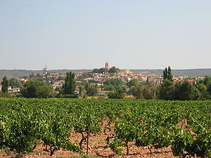
 View of Pourrières |
||
Pourrières ( Provence Pourrièro or Porrièra ) is a French municipality with 5155 inhabitants (at January 1, 2017) in the department of Var in the region Provence-Alpes-Cote d'Azur . It belongs to the canton of Saint-Maximin-la-Sainte-Baume in the Arrondissement of Brignoles .
geography
Pourrières is located on the border with the Bouches-du-Rhône department in the east of the Montagne Sainte-Victoire on the hillside over a vineyard plain that is irrigated by the Arc . The highest point is in the south of the municipality in the area of Mont Aurélien . The town center is three kilometers north of Route nationale 7 . From here it is 27 kilometers to Aix-en-Provence and 16 kilometers to Saint-Maximin-la-Sainte-Baume .
history
In 1145 the place appeared in the sources under the name De Poreriis .
Traditionally, the name is etymologically traced back to the Latin expression Campi Putridi , which refers to the mass grave that Gaius Marius left behind after he killed the Cimbri and Teutons in 102 BC. Defeated BC. Possibly the name goes back to the Provencal word for leek pòrri .
Pourrières was ruled by the Viscounts of Marseille, later, in the 16th century, it belonged to the Glandevès.

population
Pourrières was able to record a dramatic, mostly disproportionate population growth in the second half of the 20th century. In 1962 fewer than 1,000 people lived in the village. In 1999 the number of residents had more than quadrupled. The strong growth of the population continues at a reduced pace to this day.
| year | 1962 | 1968 | 1975 | 1982 | 1990 | 1999 | 2006 | 2016 |
| Residents | 905 | 980 | 1270 | 1718 | 2631 | 3905 | 4389 | 5123 |
| Sources: Cassini and INSEE | ||||||||
Attractions
- The Place de Château is a popular lookout point.
- The parish church of Saint-Trophime was built in the 14th century and expanded in the 18th century.
- The former women's monastery of the Paulanerinnen was built in 1568 and is today classified as Inscrit Monument Historique . The sturdy structure is flanked by a tower that was attached to the former Notre-Dame-du-Bois village church .
Personalities
- Paul Cézanne 's father's family comes from Pourrières.
- Germain Nouveau (1851–1920), poet, friend of Verlaine and Rimbaud, lived in Pourrières.
- The writer Joseph Pascal (1886–1982) was a teacher in Pourrières.
- The pianist Jacqueline Eymar (1922–2008) had lived in Les Hermentaires, municipality of Pourrières, since 1984.
partnership
- Pourrières has a partnership with Moyle District in Ulster, Northern Ireland.
economy
The community is dominated by agriculture. Wine, grain and melons are grown. The cooperative and independent wineries produce wines from the AOC Côtes de Provence, Sainte Victoire .

