
Mirabeau (Alpes-de-Haute-Provence)
| Mirabeau | ||
|---|---|---|

|
|
|
| region | Provence-Alpes-Cote d'Azur | |
| Department | Alpes-de-Haute-Provence | |
| Arrondissement | Digne-les-Bains | |
| Canton | Digne-les-Bains-2 | |
| Community association | Provence-Alpes agglomeration | |
| Coordinates | 44 ° 4 ′ N , 6 ° 5 ′ E | |
| height | 437–1,053 m | |
| surface | 18.22 km 2 | |
| Residents | 511 (January 1, 2017) | |
| Population density | 28 inhabitants / km 2 | |
| Post Code | 04510 | |
| INSEE code | 04122 | |
-3.JPG) Mirabeau |
||

Mirabeau is a French municipality with 511 inhabitants (at January 1, 2017) in the department of Alpes-de-Haute-Provence in the region Provence-Alpes-Cote d'Azur . It belongs to the canton of Digne-les-Bains-2 in the Arrondissement of Digne-les-Bains . The residents call themselves Mirabellens or Mirabelènes .
geography
292 hectares of the municipality mark are forested. In the south, the municipal boundary runs along the Bléone River. The neighboring communities are Barras in the north, Aiglun and Mallemoisson in the east, Le Chaffaut-Saint-Jurson in the south-east, Malijai in the south in the west and Château-Arnoux-Saint-Auban in the north-west.
Population development
| year | 1962 | 1968 | 1975 | 1982 | 1990 | 1999 | 2009 | 2016 |
|---|---|---|---|---|---|---|---|---|
| Residents | 144 | 142 | 200 | 262 | 323 | 394 | 477 | 511 |
Attractions
- Fontenelle Castle, a monument historique

Fontenelle Castle

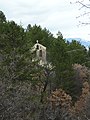
Tower of the Saint-Christol chapel
Saint-Philippe Chapel

Notre-Dame-du-Bon-Secours church


.JPG)
.JPG)
.JPG)